Image:Hungary geo divided.jpg
Un article de Wikipédia, l'encyclopédie libre.
Taille de cet aperçu : 800 × 499 pixels
Image en plus haute résolution (977 × 610 pixels, taille du fichier : 98 Kio, type MIME : image/jpeg)
| | Ce fichier provient de Wikimedia Commons?. Les informations le concernant sont affichées ci-dessous (procédure). |
 |
This map has been uploaded by Electionworld from en.wikipedia.org to enable the |
[edit] Summary
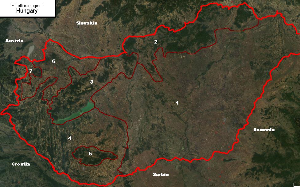
Satellite image showing the 7 main geographical regions of Hungary (in parenthesis: mayor region):
1., Great Alföld (Great Alföld)
2., Northern Medium Mountains (Northern Hills)
3., Transdanubian Medium Mountains (Transdanubia)
4., Transdanubian Hills (Transdanubia)
5., Mecsek Mountains (Transdanubia)
6., Little Alföld (Transdanubia)
7., Alpokalja (Transdanubia)
---
| Image:Hungary geo divided.jpg | P |
| Uploaded by | Cserlajos |
| Source | Satellite image published by NASA; edited (marked country and region borders) by the uploader |
| Description | Satellite image of Hungary, with geographical subdivisions. Related: Geography of Hungary. |
| Note(s) | none |
| Contact Cserlajos | |
| This template is used by Cserlajos to stamp the images uploaded by him. | |
Version without subdivisions: Image:Hungary geo deaf.jpg
[edit] Licensing

Licensing of the original image:
|
|
This file is in the public domain because it was created by NASA. NASA copyright policy states that "NASA material is not protected by copyright unless noted". (NASA copyright policy page or JPL Image Use Policy).
Deutsch | English | Español | Français | Nederlands | Português | Русский | 中文(简体) | 中文(繁體) | +/- |
|
 |
Warnings:
|
Historique du fichier
Cliquer sur une date et une heure pour voir le fichier tel qu’il était à ce moment-là
| Date et heure | Dimensions | Utilisateur | Commentaire | |
|---|---|---|---|---|
| actuel | 24 décembre 2006 à 01:53 | 977×610 (98 Kio) | Electionworld | ({{ew|en|Cserlajos}} == Summary == Satellite image showing the 7 main geographical regions of Hungary ''(in parenthesis: mayor region)'': <br>1., Great Alföld ''(Great Alföld)''<br>2., Northern Medium Mountains ''(Northern Hi) |
Pages contenant l’image
La page ci-dessous contient cette image :

