Image:Horst graben.jpg
Un article de Wikipédia, l'encyclopédie libre.
Pas de plus haute résolution disponible.
Horst_graben.jpg (346 × 260 pixels, taille du fichier : 19 Kio, type MIME : image/jpeg)
| | Ce fichier provient de Wikimedia Commons?. Les informations le concernant sont affichées ci-dessous (procédure). |
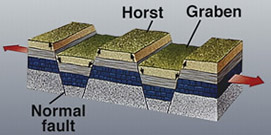
geological structure of horst and graben
| This image is in the public domain because it contains materials that originally came from the United States Geological Survey, an agency of the United States Department of Interior. For more information, see the official USGS copyright policy |
|
Historique du fichier
Cliquer sur une date et une heure pour voir le fichier tel qu’il était à ce moment-là
| Date et heure | Dimensions | Utilisateur | Commentaire | |
|---|---|---|---|---|
| actuel | 13 décembre 2005 à 19:48 | 346×260 (19 Kio) | Angrense | (Diagram of a rift formation. Source: {{PD-USGov-Interior-USGS}} from http://earthquake.usgs.gov/image_glossary/horst.html) |
| 25 août 2005 à 19:36 | 346×260 (19 Kio) | Slawojar | (geological structure of horst and graben {{PD-USGov-USGS}} en:Image:Horst graben.jpg Category:Geology) |

