Image:Germanic tribes (750BC-1AD).png
Un article de Wikipédia, l'encyclopédie libre.
Pas de plus haute résolution disponible.
Germanic_tribes_(750BC-1AD).png (537 × 376 pixels, taille du fichier : 18 Kio, type MIME : image/png)
| | Ce fichier provient de Wikimedia Commons?. Les informations le concernant sont affichées ci-dessous (procédure). |
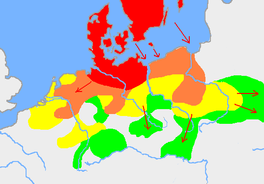
Legend copied from Wikipedia: The expansion of the Germanic tribes 750 BC – AD 1 (after the Penguin Atlas of World History 1988):
██ Settlements before 750BC
██ New settlements until 500BC
██ New settlements until 250BC
██ New settlements until AD 1
 |
This map image should be recreated using vector graphics as an SVG file. This has several advantages; see Commons:Media for cleanup for more information. If an SVG form of this image is already available, please upload it. After uploading an SVG, replace this template with template {{Vector version available|new image name.svg}} in this image. |
|
العربية | Български | Català | Česky | Dansk | Deutsch | English | Esperanto | Español | Français | 한국어 | Italiano | Magyar | Lietuvių | Nederlands | 日本語 | Polski | Português | Română | Русский | Suomi | Svenska | Türkçe | Українська | Tiếng Việt | मराठी | 中文(繁體) | 中文(简体) | +/- |
|
| Description |
Based on p. 108 in the Penguin Atlas of World History, volume 1, from the Beginning to the Eve of the French Revolution. 1988. ISBN 0-14-051054-0. Note that the map assumes that the w:Nordwestblock was Germanized before 500 BC. This is uncertain; alternative proposals hold that the area near the mouths of the Rhine came under a Germanic superstrate only in the 1st century BC. The map is drawn on en:User:Dbachmann's blank map: en::Image:Europe plain rivers.png |
|---|---|
| Source |
Originally from en.wikipedia; description page is/was here. |
| Date |
2007-01-21 (original upload date) |
| Author |
Original uploader was Berig at en.wikipedia |
| Permission (Reusing this image) |
Licensed under the GFDL by the author; PD-LAYOUT; Released under the GNU Free Documentation License. |
see also Image:Pre Migration Age Germanic.png
[edit] License information
|

[edit] Original upload log
(All user names refer to en.wikipedia)
- 2007-01-21 10:52 Berig 537×376×8 (18448 bytes) Based on p. 108 in the Penguin Atlas of World History, volume 1, from the Beginning to the Eve of the French Revolution. 1988. The map is drawn on [[User:Dbachmann]]'s blank map: [[:Image:Europe plain rivers.png]]
Historique du fichier
Cliquer sur une date et une heure pour voir le fichier tel qu’il était à ce moment-là
| Date et heure | Dimensions | Utilisateur | Commentaire | |
|---|---|---|---|---|
| actuel | 11 mars 2007 à 19:17 | 537×376 (18 Kio) | R9tgokunks | ({{Information |Description=Based on p. 108 in the Penguin Atlas of World History, volume 1, from the Beginning to the Eve of the French Revolution. 1988. ISBN 0-14-051054-0 The map is drawn on en:User:Dbachmann's blank map: [[:en::Image:Europe plain) |
| 11 février 2007 à 22:17 | 537×376 (18 Kio) | Electionworld | ({{Information |Description=Based on p. 108 in the Penguin Atlas of World History, volume 1, from the Beginning to the Eve of the French Revolution. 1988. ISBN 0-14-051054-0 The map is drawn on en:User:Dbachmann's blank map: [[:en::Image:Europe plain) |
Pages contenant l’image
Les pages ci-dessous contiennent cette image :


.png)