Image:GalwayBayMap.png
Un article de Wikipédia, l'encyclopédie libre.
Pas de plus haute résolution disponible.
GalwayBayMap.png (544 × 342 pixels, taille du fichier : 11 Kio, type MIME : image/png)
| | Ce fichier provient de Wikimedia Commons?. Les informations le concernant sont affichées ci-dessous (procédure). |
[edit] ファイルの概要
| Description |
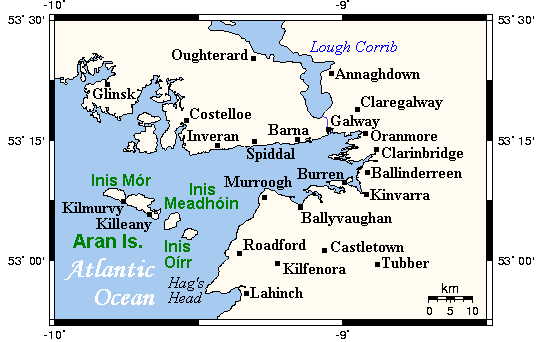
A map showing Galway Bay and nearby areas. This map's source is here, with the Kelisi's modifications, and the GMT homepage says that the tools are released under the GNU General Public License. |
|---|---|
| Source |
en:Image:GalwayBayMap.png (from en-Wikipedia) |
| Date |
2007/07/12 00:51 |
| Author | |
| Permission (Reusing this image) |
GFDL 1.2 |
[edit] Licensing
 |
Permission is granted to copy, distribute and/or modify this document under the terms of the GNU Free Documentation License, Version 1.2 or any later version published by the Free Software Foundation; with no Invariant Sections, no Front-Cover Texts, and no Back-Cover Texts. Subject to disclaimers. Asturianu | Български | Català | Deutsch | English | Español | Français | Gaeilge | Italiano | 한국어 | 日本語 | Polski | Português | Română | Türkçe | +/- |
Historique du fichier
Cliquer sur une date et une heure pour voir le fichier tel qu’il était à ce moment-là
| Date et heure | Dimensions | Utilisateur | Commentaire | |
|---|---|---|---|---|
| actuel | 25 novembre 2007 à 13:28 | 544×342 (11 Kio) | DaisyDaisy | ({{Information |Description=A map showing Galway Bay and nearby areas. This map's source is [http://www.aquarius.ifm-geomar.de/ here], with the Kelisi's modifications, and the [http://gmt.soest.hawaii.edu/ GMT homepage] says that the to) |
Pages contenant l’image
La page ci-dessous contient cette image :

