Image:Floyd1999RadarPANYNJDMP.gif
Un article de Wikipédia, l'encyclopédie libre.
Pas de plus haute résolution disponible.
Floyd1999RadarPANYNJDMP.gif (773 × 455 pixels, taille du fichier : 1 016 Kio, type MIME : image/gif)
| | Ce fichier provient de Wikimedia Commons?. Les informations le concernant sont affichées ci-dessous (procédure). |
[edit] Summary
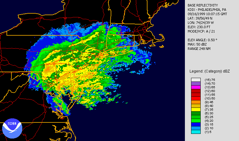
| Description |
Tropical Storm, previously Hurricane, Floyd affecting Pennsylvania, New Jersey, New York, and the Delmarva Pennisula on September 16th, 1999. Radar is long range base relectivity. Created using NCDC JAVA NEXRAD tool. |
|||||
|---|---|---|---|---|---|---|
| Source |
Source data from NCDC NEXRAD database: http://www.ncdc.noaa.gov/nexradinv/. |
|||||
| Date |
1999-09-16 |
|||||
| Author |
file created by Hello32020 |
|||||
| Permission (Reusing this image) |
|
Historique du fichier
Cliquer sur une date et une heure pour voir le fichier tel qu’il était à ce moment-là
| Date et heure | Dimensions | Utilisateur | Commentaire | |
|---|---|---|---|---|
| actuel | 23 septembre 2006 à 17:58 | 773×455 (1 016 Kio) | Hello32020 | ({{Information|Description=Tropical Storm, previously Hurricane, Floyd affecting Pennsylvania, New Jersey, New York, and the Delmarva Pennisula on September 16th, 1999. Radar is long range base relectivity. Created using NCDC [http://www.ncdc.noaa.gov/oa/r) |
Pages contenant l’image
La page ci-dessous contient cette image :

