Image:Floyd1999NCLandfall.gif
Un article de Wikipédia, l'encyclopédie libre.
Pas de plus haute résolution disponible.
Floyd1999NCLandfall.gif (773 × 455 pixels, taille du fichier : 845 Kio, type MIME : image/gif)
| | Ce fichier provient de Wikimedia Commons?. Les informations le concernant sont affichées ci-dessous (procédure). |
[edit] Summary
[edit] Summary
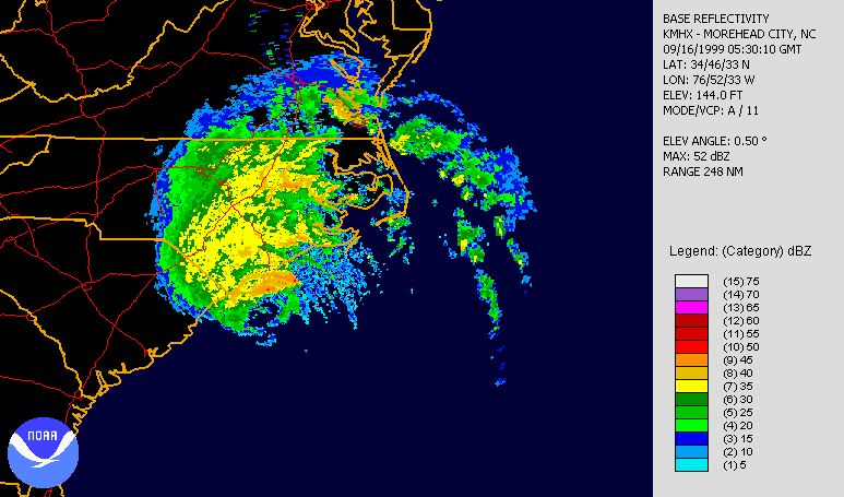
| Description |
Hurricane Floyd making landfall in North Carolina on September 16th, 1999. Radar is long range base relectivity. Created using NCDC JAVA NEXRAD tool. |
|||||
|---|---|---|---|---|---|---|
| Source |
Source data from NCDC NEXRAD database: http://www.ncdc.noaa.gov/nexradinv/. |
|||||
| Date |
1999-09-16 |
|||||
| Author |
file created by Hello32020 |
|||||
| Permission (Reusing this image) |
|
[edit] Licensing
|

Historique du fichier
Cliquer sur une date et une heure pour voir le fichier tel qu’il était à ce moment-là
| Date et heure | Dimensions | Utilisateur | Commentaire | |
|---|---|---|---|---|
| actuel | 23 septembre 2006 à 21:54 | 773×455 (845 Kio) | Hello32020 | (== Summary == {{Information|Description=Hurricane Floyd making landfall in North Carolina on September 16th, 1999. Radar is long range base relectivity. Created using NCDC [http://www.ncdc.noaa.gov/oa/radar/jnx/ JAVA NEXRAD tool]. |Source=Source data fro) |
Pages contenant l’image
La page ci-dessous contient cette image :

