Image:Emily-14-1915z-T60-discussion15-0300z.png
Un article de Wikipédia, l'encyclopédie libre.
Pas de plus haute résolution disponible.
Emily-14-1915z-T60-discussion15-0300z.png (188 × 154 pixels, taille du fichier : 50 Kio, type MIME : image/png)
| | Ce fichier provient de Wikimedia Commons?. Les informations le concernant sont affichées ci-dessous (procédure). |
Source: [1]
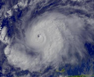
Description: Hurricane Emily regional imagery, 2005.07.14 at 1915Z. Centerpoint Latitude: 13:15:06N Longitude: 65:23:34W.
[edit] Licensing
| This image is in the public domain because it contains materials that originally came from the U.S. National Oceanic and Atmospheric Administration, taken or made during the course of an employee's official duties. |
|
Historique du fichier
Cliquer sur une date et une heure pour voir le fichier tel qu’il était à ce moment-là
| Date et heure | Dimensions | Utilisateur | Commentaire | |
|---|---|---|---|---|
| actuel | 24 août 2006 à 15:13 | 188×154 (50 Kio) | Tropische Storm Sven | (Source: [http://www.nnvl.noaa.gov/cgi-bin/index.cgi?page=items&ser=109483&large=1] Description: Hurricane Emily regional imagery, 2005.07.14 at 1915Z. Centerpoint Latitude: 13:15:06N Longitude: 65:23:34W. == Licensing == {{PD-USGov-DOC-NOAA}} ) |
Pages contenant l’image
La page ci-dessous contient cette image :

