Image:DEMap-doton-Dover.png
Un article de Wikipédia, l'encyclopédie libre.
Pas de plus haute résolution disponible.
DEMap-doton-Dover.png (139 × 300 pixels, taille du fichier : 4 Kio, type MIME : image/png)
| | Ce fichier provient de Wikimedia Commons?. Les informations le concernant sont affichées ci-dessous (procédure). |
[edit] Summary
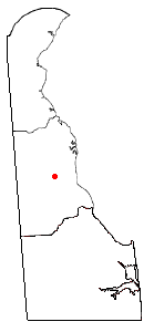
Map of Delaware, showing the position of Dover. Uploaded in en:wiki by en:User:Bumm13. Adapted from Wikipedia's DE county maps by Bumm13.
[edit] Licensing
 |
Permission is granted to copy, distribute and/or modify this document under the terms of the GNU Free Documentation License, Version 1.2 or any later version published by the Free Software Foundation; with no Invariant Sections, no Front-Cover Texts, and no Back-Cover Texts. Subject to disclaimers. Asturianu | Български | Català | Deutsch | English | Español | Français | Gaeilge | Italiano | 한국어 | 日本語 | Polski | Português | Română | Türkçe | +/- |
Historique du fichier
Cliquer sur une date et une heure pour voir le fichier tel qu’il était à ce moment-là
| Date et heure | Dimensions | Utilisateur | Commentaire | |
|---|---|---|---|---|
| actuel | 6 septembre 2006 à 00:28 | 139×300 (4 Kio) | Joao Xavier | (Map of Delaware, showing the position of Dover. Uploaded in en:wiki by en:User:Bumm13. Adapted from Wikipedia's DE county maps by Bumm13. category:Delaware) |
Pages contenant l’image
La page ci-dessous contient cette image :

