Image:Dardanelles map2.png
Un article de Wikipédia, l'encyclopédie libre.
Pas de plus haute résolution disponible.
Dardanelles_map2.png (700 × 600 pixels, taille du fichier : 123 Kio, type MIME : image/png)
| | Ce fichier provient de Wikimedia Commons?. Les informations le concernant sont affichées ci-dessous (procédure). |
[edit] Summary
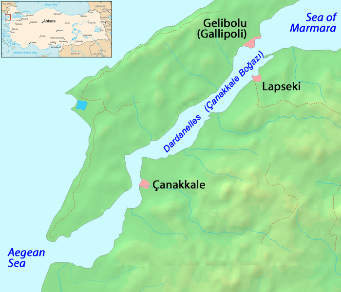
Español: Estrecho de los Dardanelos
Map of the Dardanelles. Modified version of Image:Dardanelles map.png
Image history of en:Image:Dardanelles map2.png:
(del) (cur) 23:48, 25 September 2005 . . ChrisO . . 700x600 (125686 bytes) (Amended version of :Image:Dardanelles map.png {{PD}})
| This image has been (or is hereby) released into the public domain by its author, ChrisO at the English Wikipedia project. This applies worldwide. In case this is not legally possible: |
Historique du fichier
Cliquer sur une date et une heure pour voir le fichier tel qu’il était à ce moment-là
| Date et heure | Dimensions | Utilisateur | Commentaire | |
|---|---|---|---|---|
| actuel | 13 octobre 2005 à 19:26 | 700×600 (123 Kio) | ChongDae | (This image was copied from wikipedia:en. The original description was: Amended version of Image:Dardanelles map.png {{PD}} {| border="1" ! date/time || username || edit summary |---- | 23:48, 25 September 2005 || ChrisO || <nowiki>(Amended version) |
Pages contenant l’image
La page ci-dessous contient cette image :

