Image:CraterHighlands Tanzania NASA.jpg
Un article de Wikipédia, l'encyclopédie libre.
Taille de cet aperçu : 484 × 600 pixels
Image en plus haute résolution (540 × 669 pixels, taille du fichier : 118 Kio, type MIME : image/jpeg)
| | Ce fichier provient de Wikimedia Commons?. Les informations le concernant sont affichées ci-dessous (procédure). |
[edit] Summary
| Description |
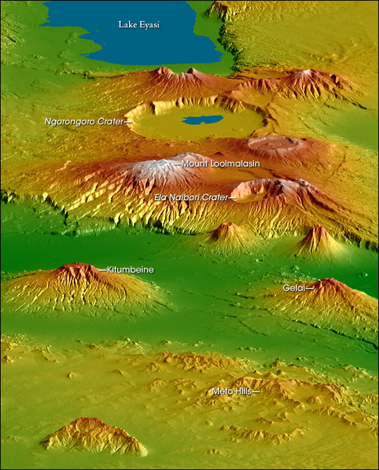
Topographical map of the w:Crater Highlands in Tanzania. Color indicates height, with lowest elevations in green and highest elevations in white. Shading shows the slope. The vertical relief has been exaggerated by a factor of 2 to reveal greater detail about the landscape. The image is oriented as though you were looking from the north toward the southwest. |
|---|---|
| Source |
http://earthobservatory.nasa.gov/Newsroom/NewImages/images.php3?img_id=17196 |
| Date |
February 2000 |
| Author |
NASA/JPL/NGA Shuttle Radar Topography team. Labels by NASA Earth Observatory newsroom. |
| Permission (Reusing this image) |
US government, public domain. |
| Other versions | Larger, unannotated version available at source URL. |
[edit] Licensing
|
|
This file is in the public domain because it was created by NASA. NASA copyright policy states that "NASA material is not protected by copyright unless noted". (NASA copyright policy page or JPL Image Use Policy).
Deutsch | English | Español | Français | Nederlands | Português | Русский | 中文(简体) | 中文(繁體) | +/- |
|
 |
Warnings:
|
Historique du fichier
Cliquer sur une date et une heure pour voir le fichier tel qu’il était à ce moment-là
| Date et heure | Dimensions | Utilisateur | Commentaire | |
|---|---|---|---|---|
| actuel | 28 avril 2006 à 19:53 | 540×669 (118 Kio) | Howcheng | ({{Information | Description=Topographical map of the w:Crater Highlands in Tanzania. Color indicates height, with lowest elevations in green and highest elevations in white. Shading shows the slope. The vertical relief has been exaggerated by a factor) |
Pages contenant l’image
Les pages ci-dessous contiennent cette image :

