Image:Cocos Plate map-fr.png
Un article de Wikipédia, l'encyclopédie libre.
Pas de plus haute résolution disponible.
Cocos_Plate_map-fr.png (655 × 463 pixels, taille du fichier : 295 Kio, type MIME : image/png)
| | Ce fichier provient de Wikimedia Commons?. Les informations le concernant sont affichées ci-dessous (procédure). |
| Description |
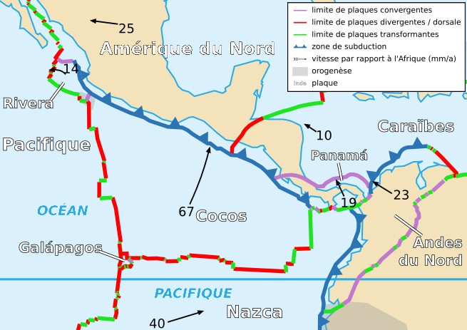
Français : Carte de la plaque des Cocos
English: Map of the Cocos Plate
|
||
|---|---|---|---|
| Source |
Cropped version by myself of Image:Tectonic_plates_boundaries_detailed-fr.svg created by Sting under CC-BY-SA |
||
| Date |
18/11/2006 |
||
| Author | |||
| Permission (Reusing this image) |
|
||
| Other versions | Scaled version of  |
Historique du fichier
Cliquer sur une date et une heure pour voir le fichier tel qu’il était à ce moment-là
| Date et heure | Dimensions | Utilisateur | Commentaire | |
|---|---|---|---|---|
| actuel | 19 novembre 2006 à 00:56 | 655×463 (295 Kio) | Rémih | ({{Information |Description={{fr|Carte de la plaque des Cocos}}{{en|Map of the Cocos Plate}} |Source=Cropped version by myself of Image:Tectonic_plates_boundaries_detailed-fr.svg created by Sting under CC-BY-SA |Date=18/11/2006 |Author=) |
Pages contenant l’image
Les pages ci-dessous contiennent cette image :

