Image:Chernyakhov.PNG
Un article de Wikipédia, l'encyclopédie libre.
Pas de plus haute résolution disponible.
Chernyakhov.PNG (777 × 471 pixels, taille du fichier : 25 Kio, type MIME : image/png)
| | Ce fichier provient de Wikimedia Commons?. Les informations le concernant sont affichées ci-dessous (procédure). |
| Description |
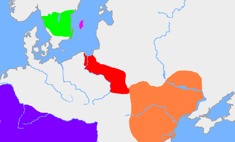
English: The green area is the traditional extent of Götaland and the pink area is the island of Gotland. The red area is the extent of the Wielbark culture in the early 3rd century, and the orange area is the Chernyakhov culture, in the early 4th century. The purple area is the Roman Empire.
The extent of the Wielbark culture is based on Zbigniew Babik: "Najstarsza warstwa nazewnicza na ziemiach polskich" Cracow 2001. The extent of the Chernyakhov culture is based on R. Wołągiewicz (1993), a map drawn by Lars Östlin, in Kaliff's Gothic Connections. Contacts between eastern Scandinavia and the southern Baltic coast 1000 BC – 500 AD (2001:29)Deutsch: Ungefähre Ausbildung der Chernjachov-Kultur im 3. Jahrhundert (orange) und der Wielbark-Kultur (rot).
|
|---|---|
| Source | |
| Date | |
| Author | |
| Permission (Reusing this image) |
see below |
[edit] Licensing

[edit] Image history
| date/time | username | edit summary |
|---|---|---|
| 22:03, 19 August 2005 | en:User:Wiglaf | |
| 20:55, 26 July 2005 | en:User:Wiglaf | |
| 13:04, 26 July 2005 | en:User:Wiglaf | |
| 12:57, 26 July 2005 | en:User:Wiglaf |
Historique du fichier
Cliquer sur une date et une heure pour voir le fichier tel qu’il était à ce moment-là
| Date et heure | Dimensions | Utilisateur | Commentaire | |
|---|---|---|---|---|
| actuel | 4 mars 2006 à 18:57 | 777×471 (25 Kio) | Maksim | (La bildo estas kopiita de wikipedia:en. La originala priskribo estas: my own map, based on User:Dbachmann's blank map. The extent of the Wielbark culture is based on Zbigniew Babik: "Najstarsza warstwa nazewnicza na ziemiach polskich" Cracow 200) |
Pages contenant l’image
Les pages ci-dessous contiennent cette image :

