Image:1960 Electoral Map.png
Un article de Wikipédia, l'encyclopédie libre.
Taille de cet aperçu : 800 × 430 pixels
Image en plus haute résolution (1 182 × 635 pixels, taille du fichier : 164 Kio, type MIME : image/png)
| | Ce fichier provient de Wikimedia Commons?. Les informations le concernant sont affichées ci-dessous (procédure). |
[edit] Summary
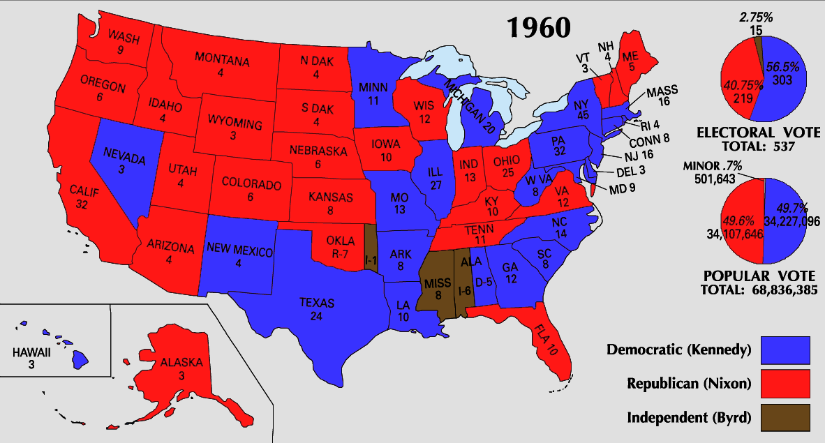
| Description |
1960 Electoral College Map |
|---|---|
| Source |
National Atlas |
| Date |
5/16/2008 |
| Author |
National Atlas |
| Permission (Reusing this image) |
PD |
| This map was obtained from an edition of the National Atlas of the United States. Like almost all works of the U.S. federal government, works from the National Atlas are in the public domain. Online access: NationalAtlas.gov | 1970 print edition: Library of Congress, Perry-Castañeda Library |
|
[edit] Licensing:
| This work is in the public domain in the United States because it is a work of the United States Federal Government under the terms of Title 17, Chapter 1, Section 105 of the US Code. See Copyright.
Note: This only applies to works of the Federal Government and not to the work of any individual U.S. state, territory, commonwealth, county, municipality, or any other subdivision. العربية | Български | Česky | Deutsch | English | Español | Français | Magyar | Italiano | 日本語 | 한국어 | Polski | Português | 中文(繁體) | 中文(简体) | +/- |
 |
| US presidential election maps |
| 1789 · 1792 · 1796 · 1800 · 1804 · 1808 · 1812 · 1816 · 1820 · 1824 · 1828 · 1832 · 1836 · 1840 · 1844 · 1848 · 1852 · 1856 · 1860 · 1864 · 1868 · 1872 · 1876 · 1880 · 1884 · 1888 · 1892 · 1896 · 1900 · 1904 · 1908 · 1912 · 1916 · 1920 · 1924 · 1928 · 1932 · 1936 · 1940 · 1944 · 1948 · 1952 · 1956 · 1960 · 1964 · 1968 · 1972 · 1976 · 1980 · 1984 · 1988 · 1992 · 1996 · 2000 · 2004 |
Historique du fichier
Cliquer sur une date et une heure pour voir le fichier tel qu’il était à ce moment-là
| Date et heure | Dimensions | Utilisateur | Commentaire | |
|---|---|---|---|---|
| actuel | 30 mai 2008 à 08:36 | 1 182×635 (164 Kio) | Tallicfan20 | |
| 24 mai 2008 à 19:31 | 1 182×635 (165 Kio) | Tallicfan20 | (better coloring) | |
| 16 mai 2008 à 19:38 | 1 182×635 (109 Kio) | Tallicfan20 | ({{Information |Description=1960 Electoral College Map |Source=National Atlas |Date=5/16/2008 |Author=National Atlas |Permission=PD |other_versions= }} {{PD-USGov-Atlas}}) |
Pages contenant l’image
La page ci-dessous contient cette image :

