Image:1630 barbarie mercator.jpg
Un article de Wikipédia, l'encyclopédie libre.
Taille de cet aperçu : 788 × 600 pixels
Image en plus haute résolution (2 727 × 2 075 pixels, taille du fichier : 2,57 Mio, type MIME : image/jpeg)
| | Ce fichier provient de Wikimedia Commons?. Les informations le concernant sont affichées ci-dessous (procédure). |
[edit] Description
| Description |
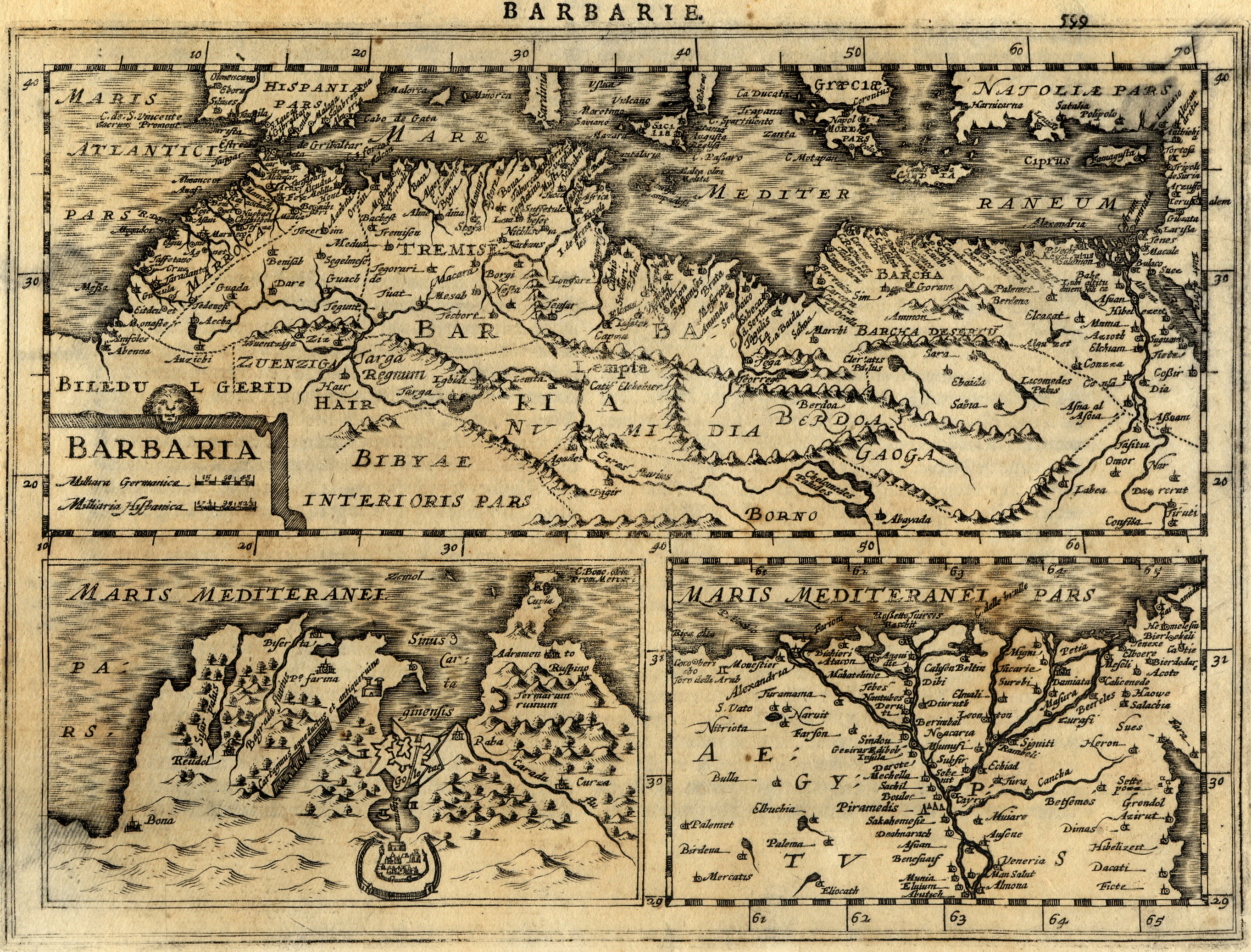
Français : Carte géographique ancienne de la Barbarie (Maghreb / Afrique du Nord / Maroc, Algérie, Tunisie, Lybie) dressée par le géographe Gerhard / Gerardus Mercator. Cette carte issue de l'Atlas Minor de Mercator a été gravée en 1630 par Jan Cloppenburgh à Amsterdam.
English: Map of Barbaria (Maghreb / Northern Africa / Morocco, Algeria, Tunisia, Lybia) made by Gerhard / Gerardus Mercator. This map, coming from Atlas Minor of Mercator has been engraved by Jan Cloppenburgh in 1630 in Amsterdam.
|
|---|---|
| Source | |
| Date |
1630 |
| Author |
Gerhard / Gerardus Mercator & Jan Cloppenburgh (reproduit par histoirepostale.net) |
| Permission (Reusing this image) |
see below |
[edit] Licensing
| This file is licensed under the Creative Commons Attribution ShareAlike 3.0 Unported License. In short: you are free to share and make derivative works of the file under the conditions that you appropriately attribute it, and that you distribute it only under a license compatible with this one.
العربية | Català | Česky | Deutsch | Ελληνικά | English | Esperanto | Español | Français | Italiano | עברית | 日本語 | 한국어 | Magyar | Nederlands | Plattdüütsch | Polski | Português | Русский | Svenska | Tiếng Việt | Українська | +/- |
Historique du fichier
Cliquer sur une date et une heure pour voir le fichier tel qu’il était à ce moment-là
| Date et heure | Dimensions | Utilisateur | Commentaire | |
|---|---|---|---|---|
| actuel | 21 avril 2008 à 15:27 | 2 727×2 075 (2,57 Mio) | Dlebouc | ({{Information |Description= |Source= |Date= |Author= |Permission= |other_versions= }} ) |
| 2 janvier 2008 à 16:25 | 2 727×2 075 (2,57 Mio) | Dlebouc | (== Description == {{Information |Description= {{fr|Carte géographique ancienne du Maghreb / Afrique du Nord (Maroc, Algérie, Tunisie, Lybie) dressée par le géographe Gerhard Mercator en 1630. {{en|Map of Maghreb / Northern Africa (Morocco, Algeria, Tu) |
Pages contenant l’image
Les pages ci-dessous contiennent cette image :
Métadonnées
Ce fichier contient des informations supplémentaires probablement ajoutées par l’appareil photo numérique ou le numériseur qui l’a acquis. Si le fichier a été modifié depuis son état original, certains détails peuvent ne pas refléter entièrement l’image modifiée.
| Description de l’image | carte ancienne / old map - Barbarie (Maroc, Algeria, Tunisie, Lybia) - Mercator - 1630 |
|---|---|
| Date de modification | 21 avril 2008 à 18:00 |
| Auteur | Mercator |
| Détenteur du droit d’auteur | Roland Goutay - Didier Lebouc - www.histoirepostale.net |
| Référence pour la latitude | Nord |
| Référence pour la longitude | Est |

