Image:Topographic map of Surtsey-fr.svg
Un article de Wikipédia, l'encyclopédie libre.

Topographic_map_of_Surtsey-fr.svg (Fichier SVG, résolution de 2453 × 1911 pixels, taille : 857 Kio)
| | Ce fichier provient de Wikimedia Commons?. Les informations le concernant sont affichées ci-dessous (procédure). |
[edit] Description
| Description |
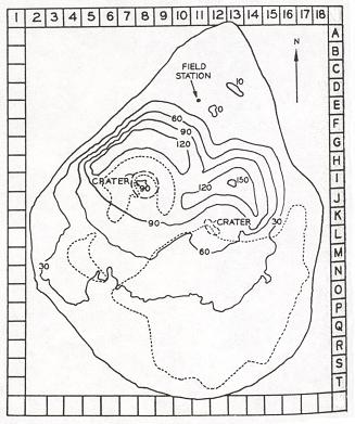
Français : Carte topographique en français de l'île Surtsey en Islande
English: Map in franch of Surtsey island in Iceland
|
|---|---|
| Source |
own work made with inkscape
Softwares used :
|
| Date |
2008-03-04 |
| Author | |
| Permission (Reusing this image) |
see below |
| This vector image was created with Inkscape. |
 |
This SVG file uses embedded text that can be easily translated into your language. Learn more.
For SVG images, you can use this page to translate it into your language. العربية | Català | Dansk | Deutsch | English | Esperanto | Español | Français | Galego | Italiano | 日本語 | Lietuvių | Magyar | Nederlands | Polski | Português | Русский | Svenska | Українська | +/- |
[edit] Licensing

Historique du fichier
Cliquer sur une date et une heure pour voir le fichier tel qu’il était à ce moment-là
| Date et heure | Dimensions | Utilisateur | Commentaire | |
|---|---|---|---|---|
| actuel | 8 mars 2008 à 13:37 | 2 453×1 911 (857 Kio) | Pinpin | |
| 8 mars 2008 à 13:04 | 2 453×1 911 (857 Kio) | Pinpin | ||
| 8 mars 2008 à 12:49 | 2 453×1 911 (857 Kio) | Pinpin | ||
| 4 mars 2008 à 22:36 | 2 453×1 911 (621 Kio) | Pinpin | ({{Information |Description={{fr|Carte topographique en français de l'île Surtsey en Islande}} {{en|Map in franch of Surtsey island in Iceland}} |Source=own work made with inkscape{{clr}} Data sources : * Altitudes : [http://www.surtsey.is/pict/kort/KORT) |
Pages contenant l’image
Les pages ci-dessous contiennent cette image :

