Image:Tet-Offensive-Map.jpg
Un article de Wikipédia, l'encyclopédie libre.
Pas de plus haute résolution disponible.
Tet-Offensive-Map.jpg (330 × 448 pixels, taille du fichier : 21 Kio, type MIME : image/jpeg)
| | Ce fichier provient de Wikimedia Commons?. Les informations le concernant sont affichées ci-dessous (procédure). |
 |
This map has been uploaded by Electionworld from en.wikipedia.org to enable the |
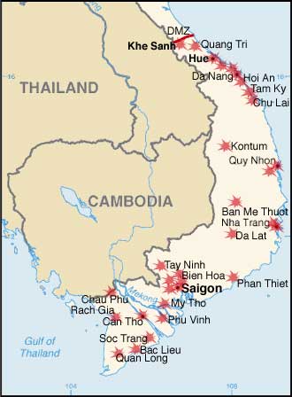
Modified by me from a CIA Factbook map.
Map showing the major targets of the Tet Offensive January-February, 1968
[edit] Licensing
| This image is in the public domain because it contains materials that originally came from the United States Central Intelligence Agency's World Factbook.
Deutsch | English | Español | Français | 日本語 | Nederlands | 한국어 | Português | தமிழ் | Magyar | +/- |
 |
Historique du fichier
Cliquer sur une date et une heure pour voir le fichier tel qu’il était à ce moment-là
| Date et heure | Dimensions | Utilisateur | Commentaire | |
|---|---|---|---|---|
| actuel | 7 décembre 2006 à 23:34 | 330×448 (21 Kio) | Electionworld | ({{ew|en|KarlBunker}} Modified by me from a CIA Factbook map. Map showing the major targets of the Tet Offensive January-February, 1968 == Licensing == {{PD-USGov-CIA-WF}} ) |
Pages contenant l’image
Les pages ci-dessous contiennent cette image :

