Image:Taal Volcano satellite image.gif
Un article de Wikipédia, l'encyclopédie libre.
Pas de plus haute résolution disponible.
Taal_Volcano_satellite_image.gif (450 × 472 pixels, taille du fichier : 214 Kio, type MIME : image/gif)
| | Ce fichier provient de Wikimedia Commons?. Les informations le concernant sont affichées ci-dessous (procédure). |
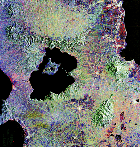
| Description |
English: Lake Taal and Taal Volcano radar satellite image. From [1].
|
|---|---|
| Source |
Transferred from en.wikipedia |
| Date |
2005-03-08 (first version); 2005-03-22 (last version) |
| Author |
Original uploader was Worldtraveller at en.wikipedia |
| Permission (Reusing this image) |
PD-USGOV-NASA. |
[edit] License information
|
|
This file is in the public domain because it was created by NASA. NASA copyright policy states that "NASA material is not protected by copyright unless noted". (NASA copyright policy page or JPL Image Use Policy).
Deutsch | English | Español | Français | Nederlands | Português | Русский | 中文(简体) | 中文(繁體) | +/- |
|
 |
Warnings:
|
[edit] Original upload log
The original description page is/was here. All following user names refer to en.wikipedia.
- 2005-03-22 20:37 Worldtraveller 450×472×8 (218708 bytes) cropped version
- 2005-03-08 16:32 Worldtraveller 450×900×8 (367977 bytes) Lake Taal and Taal Volcano radar satellite image. From [http://www.jpl.nasa.gov/radar/sircxsar/taal.html]. {{PD-USGov-NASA}}
Historique du fichier
Cliquer sur une date et une heure pour voir le fichier tel qu’il était à ce moment-là
| Date et heure | Dimensions | Utilisateur | Commentaire | |
|---|---|---|---|---|
| actuel | 10 janvier 2008 à 21:07 | 450×472 (214 Kio) | Rémih | ({{Information |Description={{en|Lake Taal and Taal Volcano radar satellite image. From [http://www.jpl.nasa.gov/radar/sircxsar/taal.html].}} |Source=Transferred from [http://en.wikipedia.org en.wikipedia] |Date=2005-03-08 (first version); 2005-03-22 (las) |
Pages contenant l’image
La page ci-dessous contient cette image :

