Image:Stonehenge plan.jpg
Un article de Wikipédia, l'encyclopédie libre.
Taille de cet aperçu : 616 × 600 pixels
Image en plus haute résolution (1 220 × 1 188 pixels, taille du fichier : 181 Kio, type MIME : image/jpeg)
| | Ce fichier provient de Wikimedia Commons?. Les informations le concernant sont affichées ci-dessous (procédure). |
Drawn by en:User:Adamsan from sources:
- Cleal, Walker, & Montague, Stonehenge in its Landscape (London, English Heritage 1995)
- Pitts, M, Hengeworld (London, Arrow 2001)
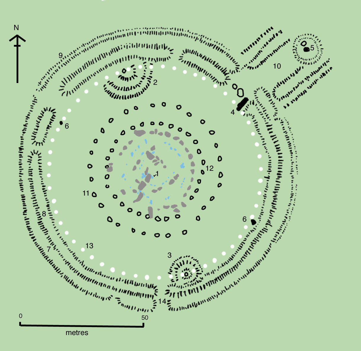
Key to plan:
- 1 = The Altar Stone, a six ton monolith of green micaceous sandstone from Wales
- 2 = barrow without a burial
- 3 = "barrows" (without burials)
- 4 = the fallen Slaughter Stone, 4.9 metres long
- 5 = the Heel Stone
- 6 = two of originally four Station Stones
- 7 = ditch
- 8 = inner bank
- 9 = outer bank
- 10 = The Avenue, a parallel pair of ditches and banks leading 3 km to the River Avon
- 11 = ring of 30 pits called the Y Holes
- 12 = ring of 30 pits called the Z Holes
- 13 = circle of 56 pits, known as the Aubrey holes
- 14 = smaller southern entrance
The site as of AD 2004. The plan omits the trilithon lintels for clarity. Holes that no longer, or never, contained stones are shown as open circles and stones visible today are shown coloured, grey for sarsen and blue for the imported stone, mainly bluestone.

Historique du fichier
Cliquer sur une date et une heure pour voir le fichier tel qu’il était à ce moment-là
| Date et heure | Dimensions | Utilisateur | Commentaire | |
|---|---|---|---|---|
| actuel | 27 mai 2005 à 15:04 | 1 220×1 188 (181 Kio) | Kdhenrik | (Drawn by en:User:Adamsan from other sources ?{{GFDL}} Key to plan: * 1 = Altar Stone, a six ton monolith of green micaceous sandstone from Wales * 2 = barrow without a burial * 3 = barrow without a burial * 4 = the fallen Slaug) |
Pages contenant l’image
La page ci-dessous contient cette image :
Métadonnées
Ce fichier contient des informations supplémentaires probablement ajoutées par l’appareil photo numérique ou le numériseur qui l’a acquis. Si le fichier a été modifié depuis son état original, certains détails peuvent ne pas refléter entièrement l’image modifiée.
| Orientation | Normale |
|---|---|
| Résolution horizontale | 150 dpi |
| Résolution verticale | 150 dpi |
| Logiciel utilisé | Adobe Photoshop 7.0 |
| Date de modification | 28 août 2004 à 17:42 |
| Espace colorimétrique | 65535 |

