Image:Satellite image of New Zealand in December 2002.jpg
Un article de Wikipédia, l'encyclopédie libre.
Taille de cet aperçu : 455 × 600 pixels
Image en plus haute résolution (4 400 × 5 800 pixels, taille du fichier : 3,39 Mio, type MIME : image/jpeg)
| | Ce fichier provient de Wikimedia Commons?. Les informations le concernant sont affichées ci-dessous (procédure). |
|
|
This file is in the public domain because it was created by NASA. NASA copyright policy states that "NASA material is not protected by copyright unless noted". (NASA copyright policy page or JPL Image Use Policy).
Deutsch | English | Español | Français | Nederlands | Português | Русский | 中文(简体) | 中文(繁體) | +/- |
|
 |
Warnings:
|
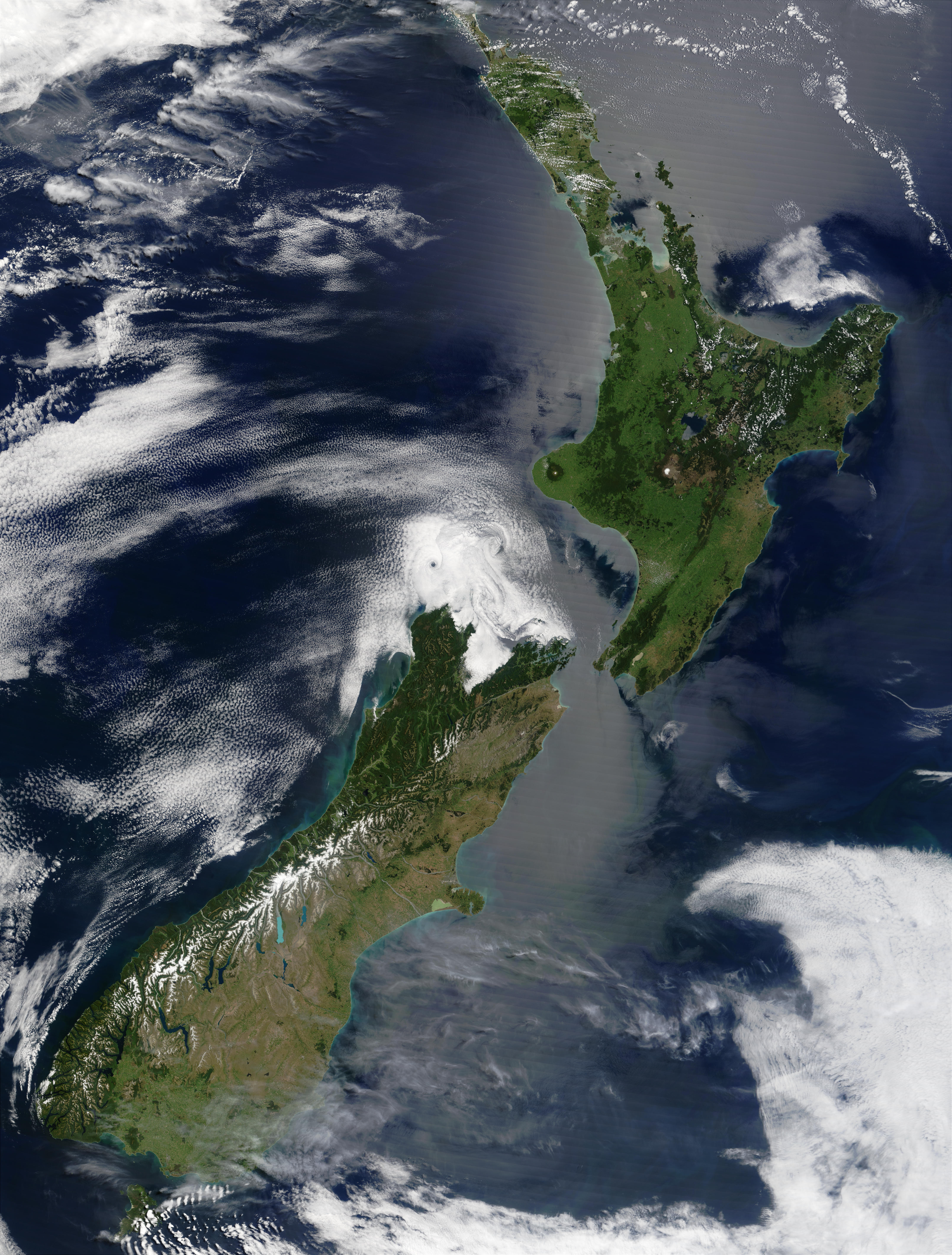
Satellite image of New Zealand in December 2002. NASA's description:
- These stunning true-color images provide a rare, cloud-free look at the island nation of New Zealand, including most of its North and South Islands. This scene was acquired by the Moderate Resolution Imaging Spectroradiometer (MODIS), flying aboard NASA’s Terra satellite, on October 23, and December 31, 2002. New Zealand is situated in the South Pacific Ocean, roughly 2,000 km (1,250 miles) southeast of Australia. Wellington, the capital of New Zealand, is located on the southern tip of the North Island, looking across Cook Strait toward South Island.
Taken from NASA's Visible Earth: [4].
| This image was selected as a picture of the day for September 12, 2005. It was captioned as followed:
English: Satellite image of New Zealand in December 2002.
Brezhoneg : Skeudenn dre loarell eus Zeland-Nevez e Kerzu 2002.
Česky: Satelitní snímek Nového Zélandu z prosince 2002
Cymraeg: Delwedd lloeren o Seland Newydd, yn Rhagfyr 2002.
Deutsch: Satellitenbild von Neuseeland in Dezember 2002
English: Satellite image of New Zealand in December 2002.
Español: Imagen de satélite de Nueva Zelanda en diciembre de 2002
Suomi: Uusi Seelanti satelliittikuvassa joulukuussa 2002.
Français : La Nouvelle-Zélande en décembre 2002, vue de l'espace
Galego: Imaxe de satélite de Nova Zelanda en decembro de 2002.
日本語: 2002年12月のニュージーランドの衛星写真
Latina: Photographema satellitium Novae Zelandiae, Decembre 2002
Nederlands: Satelliet foto van Nieuw-Zeeland in december 2002.
Norsk (nynorsk): Satelittbilde av New Zealand frå desember 2002.
Polski: Satelitarny obraz Nowej Zelandii w grudniu 2002
Português: Imagem satélite da Nova Zelândia em Dezembro de 2002.
Русский: Спутниковый снимок Новой Зеландии в декабре 2002.
Slovenčina: Satelitný záber na Nový Zéland z decembra 2002
ไทย: ภาพถ่ายดาวเทียมประเทศนิวซีแลนด์เมื่อเดือนธันวาคม พ.ศ. ๒๕๔๕
|
Historique du fichier
Cliquer sur une date et une heure pour voir le fichier tel qu’il était à ce moment-là
| Date et heure | Dimensions | Utilisateur | Commentaire | |
|---|---|---|---|---|
| actuel | 3 mai 2005 à 17:51 | 4 400×5 800 (3,39 Mio) | Hautala | ({{PD-USGov-NASA}} Satellite image of New Zealand in December 2002. NASA's description: :These stunning true-color images provide a rare, cloud-free look at the island nation of New Zealand, including most of its North and South Islands. This scene was ac) |
Pages contenant l’image
Les pages ci-dessous contiennent cette image :

