Image:Satellite image of Madagascar in September 2003.jpg
Un article de Wikipédia, l'encyclopédie libre.
Taille de cet aperçu : 312 × 598 pixels
Image en plus haute résolution (3 214 × 6 164 pixels, taille du fichier : 2,94 Mio, type MIME : image/jpeg)
| | Ce fichier provient de Wikimedia Commons?. Les informations le concernant sont affichées ci-dessous (procédure). |
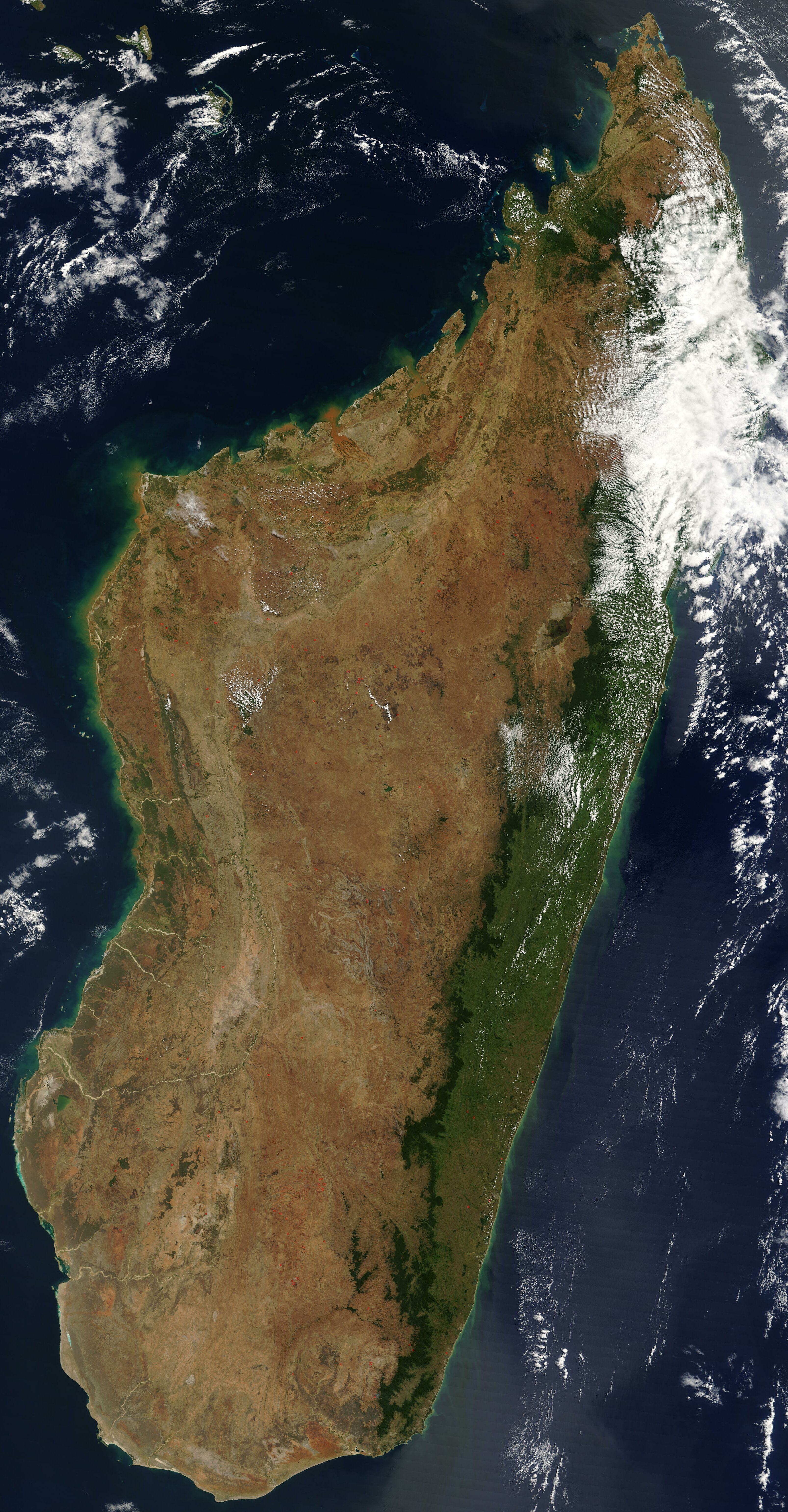
Satellite image of Madagascar in September 2003.
Slightly cropped, original taken from NASA's Visible Earth: [1]. Original description:
- The world's fourth largest island, Madagascar, is featured in this Moderate Resolution Imaging Spectroradiometer (MODIS) image taken by the Terra satellite on September 10, 2003. Several active fires, marked with red dots, burn in the central highlands, which are primarily covered with rice fields. The fires are probably controlled burns to clear farmland. The narrow strip of green along the east coast of the island is a rain forest. The west coast is lined with baobabs, a desert tree with a fat trunk, and thorny forest.
|
|
This file is in the public domain because it was created by NASA. NASA copyright policy states that "NASA material is not protected by copyright unless noted". (NASA copyright policy page or JPL Image Use Policy).
Deutsch | English | Español | Français | Nederlands | Português | Русский | 中文(简体) | 中文(繁體) | +/- |
|
 |
Warnings:
|
| This image was selected as a picture of the day for November 1, 2005. It was captioned as followed:
English: Satellite image of Madagascar in September
Česky: Pohled ze satelitu na Madagaskar (září 2003)
Cymraeg: Delwedd lloeren o Madagascar (Medi 2003)
Deutsch: Satellitenbild von Madagaskar
English: Satellite image of Madagascar in September
Español: Imagen satelital de Madagascar en septiembre
Suomi: Syyskuinen Madagaskar satelliittikuvassa
Français : Image satellite de Madagascar (septembre 2003)
Gaeilge: Radharc Madagascar ó spás.
Italiano: Immagine satellitare dell'isola di Madagascar
Latina: Madagascariae imago satellitia
Norsk (bokmål): Satellittbilde av Madagaskar.
Nederlands: Sattellietfoto van Madagaskar in september.
Norsk (nynorsk): Satellittbilde av Madagaskar.
Polski: Satelitarny obraz Madagaskaru (wrzesień 2003)
Русский: Спутниковая фотография Мадагаскара, четвёртого по величине острова в мире, сделанная 10 сентября 2003 года.
Slovenčina: Satelitná snímka Madagaskaru (spetember 2003)
Svenska: Satellitbild av Madagaskar.
ไทย: ภาพถ่ายดาวเทียมเกาะมาดากัสการ์เมื่อเดือนกันยายน พ.ศ. ๒๕๔๖
中文(简体): 2003年9月马达加斯加的卫星照片
|
Historique du fichier
Cliquer sur une date et une heure pour voir le fichier tel qu’il était à ce moment-là
| Date et heure | Dimensions | Utilisateur | Commentaire | |
|---|---|---|---|---|
| actuel | 7 janvier 2005 à 14:51 | 3 214×6 164 (2,94 Mio) | Hautala | ({{PD-USGov-NASA}} Satellite image of Madagascar in September 2003. Slightly cropped, original taken from NASA's Visible Earth http://visibleearth.nasa.gov/cgi-bin/viewrecord?25841 . Original description: The world’s fourth largest island, Madagasca) |
Pages contenant l’image
Les pages ci-dessous contiennent cette image :

