Image:Samaritan communities map.png
Un article de Wikipédia, l'encyclopédie libre.
Pas de plus haute résolution disponible.
Samaritan_communities_map.png (500 × 333 pixels, taille du fichier : 16 Kio, type MIME : image/png)
| | Ce fichier provient de Wikimedia Commons?. Les informations le concernant sont affichées ci-dessous (procédure). |
| Description |
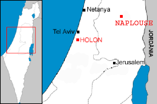
Localization of the two samaritan communities : Holon in Israel, and Nablus in the west bank. |
|---|---|
| Source | |
| Date |
4 January 2007 (UTC) |
| Author |
modified by Christophe cagé 09:54, 4 January 2007 (UTC) |
| Permission (Reusing this image) |
see license (Public domain) of original image |
| Other versions | Image:Localització de Holon.png |
[edit] Licensing
| This image has been (or is hereby) released into the public domain by its author, Rf at the wikipedia project. This applies worldwide. In case this is not legally possible: |
Historique du fichier
Cliquer sur une date et une heure pour voir le fichier tel qu’il était à ce moment-là
| Date et heure | Dimensions | Utilisateur | Commentaire | |
|---|---|---|---|---|
| actuel | 4 janvier 2007 à 11:54 | 500×333 (16 Kio) | Christophe cagé | ({{Information |Description=Localization of the two samaritan communities : Holon in Israel, and Nablus in the west bank. |Source=Image:Localització de Holon.png |Date=~~~~ |Author=modified by ~~~~ |Permission=see license (Public domain) of original ) |
Pages contenant l’image
La page ci-dessous contient cette image :

