Image:RangeMap-PlainsZebra.GIF
Un article de Wikipédia, l'encyclopédie libre.
Pas de plus haute résolution disponible.
RangeMap-PlainsZebra.GIF (341 × 341 pixels, taille du fichier : 6 Kio, type MIME : image/gif)
| | Ce fichier provient de Wikimedia Commons?. Les informations le concernant sont affichées ci-dessous (procédure). |
 |
This map image should be recreated using vector graphics as an SVG file. This has several advantages; see Commons:Media for cleanup for more information. If an SVG form of this image is already available, please upload it. After uploading an SVG, replace this template with template {{Vector version available|new image name.svg}} in this image. |
|
العربية | Български | Català | Česky | Dansk | Deutsch | English | Esperanto | Español | Français | 한국어 | Italiano | Magyar | Lietuvių | Nederlands | 日本語 | Polski | Português | Română | Русский | Suomi | Svenska | Türkçe | Українська | Tiếng Việt | मराठी | 中文(繁體) | 中文(简体) | +/- |
|
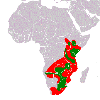
Range Map Plains Zebra. Historical range: Red. Present range: Green. Based on maps in "Moelman, P.D. 2002. Equids. Zebras, Assess and Horses. Status Survey and Conservation Action Plan. IUCN/SSC Equid Specialist Group. IUCN, Gland, Switzerland." (http://www.iucn.org/themes/ssc/pubs/sscaps.htm#Equids2002). Author: Peter Maas 11:15, 6 April 2006 (UTC)

Historique du fichier
Cliquer sur une date et une heure pour voir le fichier tel qu’il était à ce moment-là
| Date et heure | Dimensions | Utilisateur | Commentaire | |
|---|---|---|---|---|
| actuel | 6 avril 2006 à 13:30 | 341×341 (6 Kio) | Pmaas | (Range Map Plains Zebra. Historical range: Red. Present range: Green. Based on maps in "Duncan, P. (ed.). 1992. Zebras, Asses, and Horses: an Action Plan for the Conservation of Wild Equids. IUCN/SSC Equid Specialist Group. IUCN, Gland, Switzerland". Autho) |
| 6 avril 2006 à 13:15 | 341×341 (6 Kio) | Pmaas | (Range Map Plains Zebra. Historical range: Red. Present range: Green. Based on maps in "Duncan, P. (ed.). 1992. Zebras, Asses, and Horses: an Action Plan for the Conservation of Wild Equids. IUCN/SSC Equid Specialist Group. IUCN, Gland, Switzerland". Aut) |
Pages contenant l’image
La page ci-dessous contient cette image :

