Image:Rajendra territories cl.png
Un article de Wikipédia, l'encyclopédie libre.
Pas de plus haute résolution disponible.
Rajendra_territories_cl.png (482 × 430 pixels, taille du fichier : 119 Kio, type MIME : image/png)
| | Ce fichier provient de Wikimedia Commons?. Les informations le concernant sont affichées ci-dessous (procédure). |
| Description |
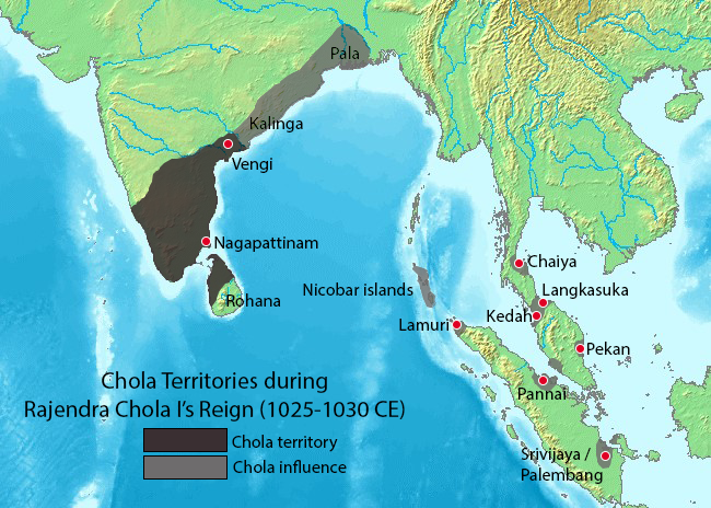
SummaryMap showing the extent of the Chola empire during Rajendra Chola I. Source of map: http://www2.demis.nl/mapserver/mapper.asp (mention : "Disclaimer: With this statement DEMIS BV grants you permission to freely copy the PNG images returned by our server and use them for your own purposes, including web pages. We would appreciate a reference to our server but such a reference is not required, nor do we take responsibility for the accuracy or quality of the maps". at http://www2.demis.nl/mapserver/DataSrc.htm) Modified by myself using Adobe Photoshop |
|---|---|
| Source | No source specified. Please edit this image description and provide a source. |
| Date | |
| Author |
User Venu62 on en.wikipedia |
| Permission (Reusing this image) |
|
| Other versions |
Originally from en.wikipedia; description page is (was) here
|

Historique du fichier
Cliquer sur une date et une heure pour voir le fichier tel qu’il était à ce moment-là
| Date et heure | Dimensions | Utilisateur | Commentaire | |
|---|---|---|---|---|
| actuel | 25 juin 2006 à 15:40 | 482×430 (119 Kio) | Nicke L | ({{Information| |Description= == Summary == Map showing the extent of the Chola empire during Rajendra Chola I. Source of map: http://www2.demis.nl/mapserver/mapper.asp (mention : "Disclaimer: With this statement DEMIS BV grants you permission to freely c) |
Pages contenant l’image
La page ci-dessous contient cette image :

