Image:Principaux Bidonvilles.png
Un article de Wikipédia, l'encyclopédie libre.
Taille de cet aperçu : 800 × 370 pixels
Image en plus haute résolution (1 357 × 628 pixels, taille du fichier : 66 Kio, type MIME : image/png)
| | Ce fichier provient de Wikimedia Commons?. Les informations le concernant sont affichées ci-dessous (procédure). |
[edit] Description
| Description |
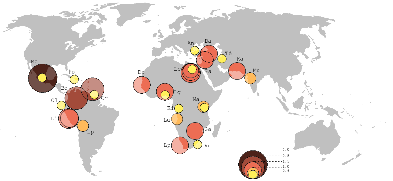
English: Map representing the location of the 30 biggest "mega-slums" in the World, according to Mike Davis (see below). Data compiled from various sources, taking average values. The circles' size and color indicate the number of inhabitants in millions, while the letter indicate the nameof the city (see table below). Note that some cities have several "mega-slums" while other cities may have more inhabitants living in slums, but scattered in many small slums rather than in a few "mega-slums", particularly in South Asia.
Français : Carte présentant la localisation des 30 plus grands 'mégabidonvilles' au monde, d'après Mike Davis. Données compilées à partir de plusieurs sources, en prenant des valeurs médianes plutôt qu'extrêmes. La taille et la couleur des cercles indique le nombre d'habitants du bidonville en millions, les lettres indiquent le nom de la ville (voir tableau plus bas). Notez que certaines villes possèdent plusieurs "méga-bidonvilles", et que d'autres villes peuvent avoir davantage d'habitants en bidonvilles, mais répartis dans plusieurs petits quartiers plutôt que dans quelques gros ; c'est le cas notamment en Asie du Sud.
|
|
|---|---|---|
| Source |
|
|
| Date |
25/08/2007 |
|
| Author | ||
| Permission (Reusing this image) |
PD-self |
|
| Other versions |
|

| This image has been improved by Wikigraphists of the French Graphics Lab. You can also propose images to improve as well.
Cette image a été améliorée par les Wikigraphistes de l'Atelier graphique. Vous pouvez aussi proposer des images à améliorer. |
[edit] Licensing

[edit] Raw data
| Slum's name | Code on map | City (country) | Population in 2005 (millions) |
|---|---|---|---|
| Nezal / Chalco / Izta | Me |
Mexico (Mexique) | 4,0 |
| Libertador | Cr |
Caracas (Venezuela) | 2,2 |
| El Sur / Ciudad Bolivar | Bo |
Bogotá (Colombie) | 2,0 |
| San Juan de Luringancho | Li |
Lima (Pérou) | 1,5 |
| Cono Sur | Li |
Lima (Pérou) | 1,5 |
| Ajegunle | Lg |
Lagos (Nigeria) | 1,5 |
| Sadr City | Ba |
Bagdad (Irak) | 1,5 |
| Soweto | Ga |
Gauteng (Afrique du Sud) | 1,5 |
| Gaza | Pa |
Palestine | 1,3 |
| Orangi Township | Ka |
Karâchi (Pakistan) | 1,2 |
| Cape Flats | Lp |
Le Cap (Afrique du Sud) | 1,2 |
| Pikine | Da |
Dakar (Sénégal) | 1,2 |
| Imbaba | Lc |
Le Caire (Égypte) | 1,0 |
| Ezbet el-Haggana | Lc |
Le Caire (Égypte) | 1,0 |
| Cazenga | Lu |
Luanda (Angola) | 0,8 |
| Dharavi | Mu |
Mumbai (Inde) | 0,8 |
| fr:Kibera | Na |
Nairobi (Kenya) | 0,8 |
| El Alto | Lp |
La Paz (Bolivie) | 0,8 |
| La Cité des Morts | Lc |
Le Caire (Égypte) | 0,8 |
| Sucre | Cr |
Caracas (Venezuela) | 0,6 |
| Eslamshahr | Te |
Téhéran (Iran) | 0,6 |
| Tlalpan | Me |
Mexico (Mexique) | 0,6 |
| Inanda INK | Du |
Durban (Afrique du Sud) | 0,5 |
| Manshiet Nasser | Lc |
Le Caire (Égypte) | 0,5 |
| Altindag | An |
Ankara (Turquie) | 0,5 |
| Mathare | Na |
Nairobi (Kenya) | 0,5 |
| Aguas Blanca | Cl |
Cali (Colombie) | 0,5 |
| Agege | Lg |
Lagos (Nigeria) | 0,5 |
| Cité-Soleil | Po |
Port-au-Prince (Haïti) | 0,5 |
| Masina | Ki |
fr:Kinshasa (RDC) | 0,5 |
Historique du fichier
Cliquer sur une date et une heure pour voir le fichier tel qu’il était à ce moment-là
| Date et heure | Dimensions | Utilisateur | Commentaire | |
|---|---|---|---|---|
| actuel | 27 août 2007 à 09:32 | 1 357×628 (66 Kio) | Walké | |
| 27 août 2007 à 09:26 | 1 357×628 (59 Kio) | Walké | ||
| 27 août 2007 à 09:21 | 1 357×628 (59 Kio) | Walké | ||
| 26 août 2007 à 13:49 | 1 357×628 (62 Kio) | Walké | ||
| 26 août 2007 à 12:43 | 1 357×628 (46 Kio) | Walké | ||
| 25 août 2007 à 19:58 | 1 357×628 (41 Kio) | Walké | ||
| 25 août 2007 à 19:37 | 1 357×628 (30 Kio) | Walké | ||
| 25 août 2007 à 19:31 | 1 357×628 (29 Kio) | Walké | ||
| 25 août 2007 à 19:31 | 1 357×628 (28 Kio) | Walké | ||
| 25 août 2007 à 19:11 | 1 357×628 (28 Kio) | Walké | ||
| 25 août 2007 à 18:45 | 1 357×628 (26 Kio) | Walké | ||
| 25 août 2007 à 18:19 | 1 357×628 (30 Kio) | Walké | ||
| 25 août 2007 à 17:51 | 1 357×628 (24 Kio) | Walké | ({{Information |Description= Carte présentant les 30 plus grands mégabidonvilles au monde |Source=Mike Davis, Le pire des mondes possibles, De l'explosion urbaine au bidonville global, La Découverte, 2006 , et Image:BlankMap-World-noborders.png. |D) |
Pages contenant l’image
Les pages ci-dessous contiennent cette image :

