Image:Offa dioceses.gif
Un article de Wikipédia, l'encyclopédie libre.
Pas de plus haute résolution disponible.
Offa_dioceses.gif (670 × 566 pixels, taille du fichier : 174 Kio, type MIME : image/gif)
| | Ce fichier provient de Wikimedia Commons?. Les informations le concernant sont affichées ci-dessous (procédure). |
| Description |
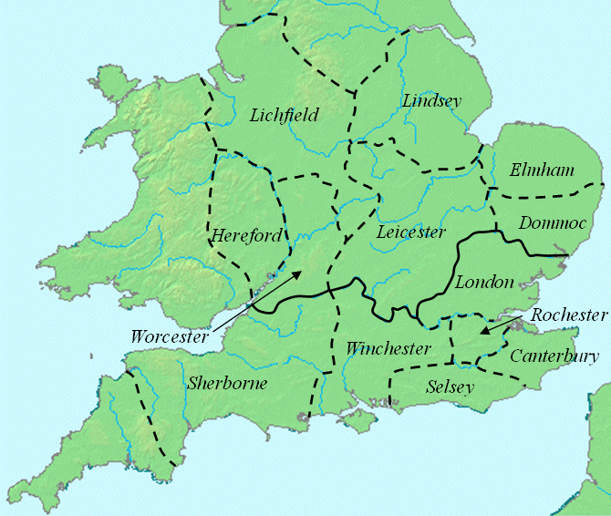
This map shows dioceses in England during the reign of Offa. The boundary between the archdioceses of Lichfield and Canterbury is shown in bold. This file was created using DMIS. On that site it is stated that "We do not claim copyright on the images, so you can use them for Wikipedia." This map is based on a map found in Patrick Wormald's "The Age of Bede and Aethelbald", in James Campbell et al., The Anglo-Saxons, p. 71. |
|---|---|
| Source |
initially on w:en:Image:Offa dioceses.gif |
| Date |
2008-1-6 |
| Author | |
| Permission (Reusing this image) |
see below |
The original upload says
- current 16:51, 6 January 2008 w:en:User:Mike Christie (Talk | contribs) 670×566 174 KB This map shows dioceses in England during the reign of Offa. The boundary between the archdioceses of Lichfield and Canterbury is shown in bold. This file was created using DMIS. On that site it is [http://supp
| This image has been (or is hereby) released into the public domain by its author, Mike Christie at the en project. This applies worldwide. In case this is not legally possible: |
Historique du fichier
Cliquer sur une date et une heure pour voir le fichier tel qu’il était à ce moment-là
| Date et heure | Dimensions | Utilisateur | Commentaire | |
|---|---|---|---|---|
| actuel | 8 mars 2008 à 16:31 | 670×566 (174 Kio) | Jborme | ({{Information |Description=This map shows dioceses in England during the reign of Offa. The boundary between the archdioceses of Lichfield and Canterbury is shown in bold. This file was created using [http://www.demis.nl/home/pages/home.htm DMIS]. On t) |
Pages contenant l’image
La page ci-dessous contient cette image :

