Image:Northwest-territory-usa-1787.png
Un article de Wikipédia, l'encyclopédie libre.
Pas de plus haute résolution disponible.
Northwest-territory-usa-1787.png (349 × 276 pixels, taille du fichier : 61 Kio, type MIME : image/png)
| | Ce fichier provient de Wikimedia Commons?. Les informations le concernant sont affichées ci-dessous (procédure). |
[edit] Summary
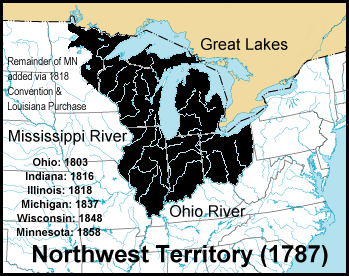
The Northwest Territory of the United States, circa 1787, time of the Northwest Ordinance. Created October 2004 by jengod. Based on a public domain U.S. government map: http://nationalatlas.gov/printable/images/preview/outline/rivers_lakes(u).gif
w:en:Image:Northwest-territory-usa-1787.png by Jengod, 10/13/2004 22:33 (UTC)
[edit] Licensing
 |
Permission is granted to copy, distribute and/or modify this document under the terms of the GNU Free Documentation License, Version 1.2 or any later version published by the Free Software Foundation; with no Invariant Sections, no Front-Cover Texts, and no Back-Cover Texts. Subject to disclaimers. Asturianu | Български | Català | Deutsch | English | Español | Français | Gaeilge | Italiano | 한국어 | 日本語 | Polski | Português | Română | Türkçe | +/- |
Historique du fichier
Cliquer sur une date et une heure pour voir le fichier tel qu’il était à ce moment-là
| Date et heure | Dimensions | Utilisateur | Commentaire | |
|---|---|---|---|---|
| actuel | 8 octobre 2006 à 06:05 | 349×276 (61 Kio) | Yassie | (w:en:Image:Northwest-territory-usa-1787.png by Jengod, 10/13/2004 22:33 (UTC)) |
Pages contenant l’image
Les pages ci-dessous contiennent cette image :


.gif)