Image:North ossetia map.png
Un article de Wikipédia, l'encyclopédie libre.
Pas de plus haute résolution disponible.
North_ossetia_map.png (304 × 377 pixels, taille du fichier : 23 Kio, type MIME : image/png)
| | Ce fichier provient de Wikimedia Commons?. Les informations le concernant sont affichées ci-dessous (procédure). |

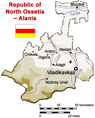
Map of North Ossetia, Russia (from mapping by US Dept of State - 2762 6-94 STATE (INR/GGI))
Originally uploaded to English Wikipedia by ChrisO.
| This image is a work of a United States Department of State employee, taken or made during the course of the person's official duties. As a work of the U.S. federal government, the image is in the public domain per 17 U.S.C. § 101 and § 105. |
 |
Historique du fichier
Cliquer sur une date et une heure pour voir le fichier tel qu’il était à ce moment-là
| Date et heure | Dimensions | Utilisateur | Commentaire | |
|---|---|---|---|---|
| actuel | 6 avril 2005 à 15:50 | 304×377 (23 Kio) | Dbenbenn | (Reverted to earlier revision) |
| 6 avril 2005 à 15:50 | 300×330 (39 Kio) | Dbenbenn | (original version, uploaded by en:User:ChrisO at 12:19, 1 Sep 2004) | |
| 29 mars 2005 à 14:51 | 304×377 (23 Kio) | Fbd | (Image from the en.wikipedia. {{PD-USGov}}) |
Pages contenant l’image
Les pages ci-dessous contiennent cette image :

