Image:New C-S System Overview.jpg
Un article de Wikipédia, l'encyclopédie libre.
Pas de plus haute résolution disponible.
New_C-S_System_Overview.jpg (657 × 541 pixels, taille du fichier : 146 Kio, type MIME : image/jpeg)
| | Ce fichier provient de Wikimedia Commons?. Les informations le concernant sont affichées ci-dessous (procédure). |
 |
This image should be recreated using vector graphics as an SVG file. This has several advantages; see Commons:Media for cleanup for more information. If an SVG form of this image is already available, please upload it. After uploading an SVG, replace this template with template {{Vector version available|new image name.svg}} in this image. |
|
العربية | Български | Català | Česky | Dansk | Deutsch | English | Esperanto | Español | Français | 한국어 | Italiano | Magyar | Lietuvių | Nederlands | 日本語 | Polski | Português | Română | Русский | Suomi | Svenska | Türkçe | Українська | Tiếng Việt | मराठी | 中文(繁體) | 中文(简体) | +/- |
|
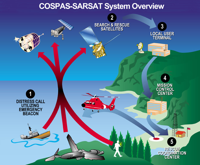
Cospas-Sarsat system overview of satellite based distress alerts using emergency beacons. Downloaded from http://www.sarsat.noaa.gov/.
| This image is in the public domain because it contains materials that originally came from the U.S. National Oceanic and Atmospheric Administration, taken or made during the course of an employee's official duties. |
|
Historique du fichier
Cliquer sur une date et une heure pour voir le fichier tel qu’il était à ce moment-là
| Date et heure | Dimensions | Utilisateur | Commentaire | |
|---|---|---|---|---|
| actuel | 22 août 2005 à 20:05 | 657×541 (146 Kio) | Sdo | (Cospas-Sarsat system overview of satellite based distress alerts using emergency beacons. Downloaded from [http://www.sarsat.noaa.gov/ http://www.sarsat.noaa.gov/]. {{PD-USGov-NOAA}}) |
Pages contenant l’image
La page ci-dessous contient cette image :

