Image:LouisianaPurchase-fr.png
Un article de Wikipédia, l'encyclopédie libre.
Taille de cet aperçu : 800 × 542 pixels
Image en plus haute résolution (1 480 × 1 003 pixels, taille du fichier : 322 Kio, type MIME : image/png)
| | Ce fichier provient de Wikimedia Commons?. Les informations le concernant sont affichées ci-dessous (procédure). |
[edit] Summary
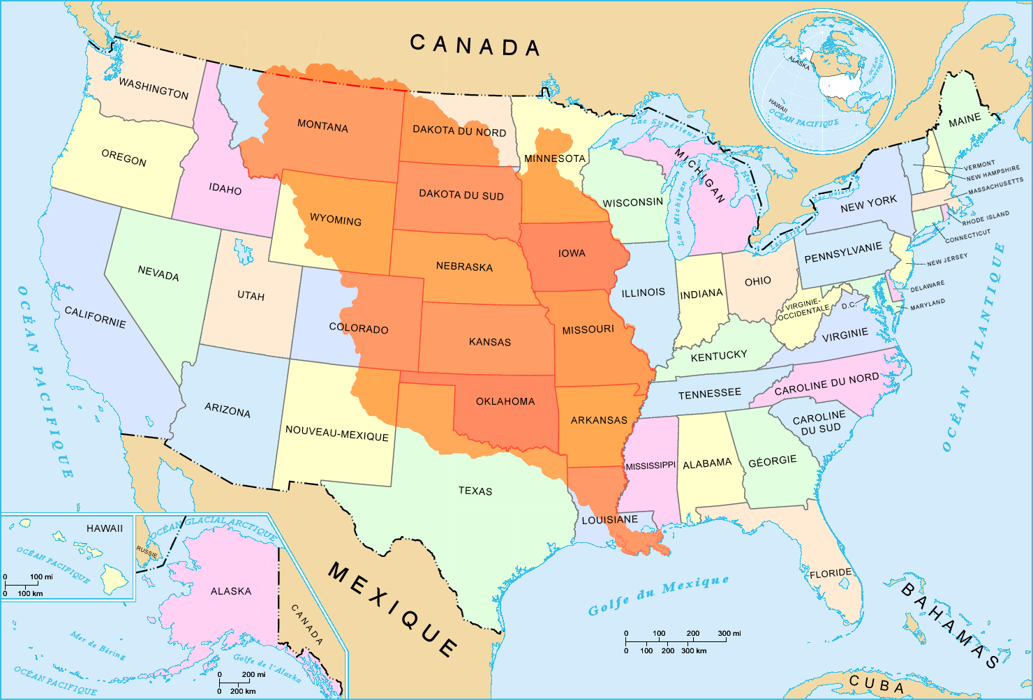
L'achat de la Louisiane en 1803
Cartes utilisées : Image:US_map_-_states-fr.png et Image:USA_territorial_acquisitions-fr.png
English: This map was made or improved by the Wikigraphists of the Atelier graphique. You can propose maps or images to clean up and improve as well.
Esperanto: Ĉi tiu mapo estis kreita aŭ plibonigita de la Vikigrafistoj el la Grafika laborgrupo. Vi ankaŭ povas tie proponi mapojn aŭ bildojn plibonigendajn.
Español: Este mapa ha sido confeccionado o mejorado por los Wikígrafos del Taller gráfico. Puedes proponer la mejora de cualquier imagen a través de la página de Peticiones.
Français : Cette carte a été créée ou améliorée par les Wikigraphistes de l'Atelier graphique. Vous pouvez également y proposer des cartes ou des images à améliorer.
Türkçe: Bu harita Atelier graphique'ten Wikigraphistes'ler tarafından yapıldı veya geliştirildi. Siz de haritalar veya resimleri temizlemek veya geliştirmek için teklif edebilirsiniz.
[edit] Licensing

Historique du fichier
Cliquer sur une date et une heure pour voir le fichier tel qu’il était à ce moment-là
| Date et heure | Dimensions | Utilisateur | Commentaire | |
|---|---|---|---|---|
| actuel | 13 mai 2006 à 04:21 | 1 480×1 003 (322 Kio) | Sting | (New French version) |
| 11 mai 2006 à 14:24 | 800×495 (130 Kio) | Chris93 | (L'achat de la Louisiane en 1803 En attente de traduction. from de:wiki (User de:Benutzer:ErnstA Category:Maps of Louisiana Category:USA Territorial Growth Maps Category:Historical maps of the United States ) |
Pages contenant l’image
Les pages ci-dessous contiennent cette image :
- Thomas Jefferson
- Relations entre les États-Unis et la France
- Portail:Géographie
- Portail:Géographie/Nouvelles
- Vente de la Louisiane
- Louisiane (Nouvelle-France)
- Wikipédia:Sélection
- Wikipédia:AccueilLumièreSur/juin 2006
- Wikipédia:AccueilLumièreSur/5 juin 2006
- Wikipédia:Sélection/Cliopédia
- Portail:Nouvelle-France/Lumière sur.../Archives
- Portail:Nouvelle-France/Lumière sur.../Archives/052007
- Wikipédia:Sélection/États-Unis d'Amérique
- Wikipédia:Lumière sur/Louisiane (Nouvelle-France)
- Wikipédia:Sélection/Géographie
- Territoire de Louisiane

