Image:Litla dimun map.jpg
Un article de Wikipédia, l'encyclopédie libre.
Pas de plus haute résolution disponible.
Litla_dimun_map.jpg (401 × 273 pixels, taille du fichier : 21 Kio, type MIME : image/jpeg)
| | Ce fichier provient de Wikimedia Commons?. Les informations le concernant sont affichées ci-dessous (procédure). |
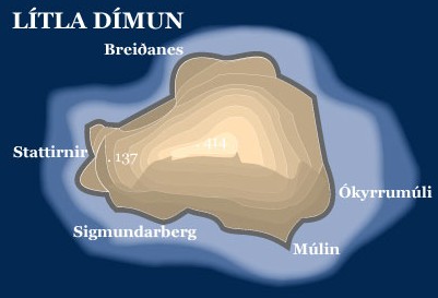
- Topopgraphic map of the island of Lítla Dímun, Faroe Islands
- Graphics: Anker Eli Petersen
- Source: Faroestamps.fo
| This image is in the public domain because it was released by the copyright holder Postverk Føroya - Philatelic Office. More information here
|
|
Historique du fichier
Cliquer sur une date et une heure pour voir le fichier tel qu’il était à ce moment-là
| Date et heure | Dimensions | Utilisateur | Commentaire | |
|---|---|---|---|---|
| actuel | 28 juin 2005 à 10:28 | 401×273 (21 Kio) | Arne List | (*Topopgraphic map of the island of Lítla Dímun, Faroe Islands *Graphics: Anker Eli Petersen *Source: [http://www.faroestamps.fo/?side=cf860f1610d1ec7342844c79d9ddd36e Faroestamps.fo] {{PD}}) |
Pages contenant l’image
La page ci-dessous contient cette image :

