Image:Kerguelen-Plateau-Topography.jpg
Un article de Wikipédia, l'encyclopédie libre.
Pas de plus haute résolution disponible.
Kerguelen-Plateau-Topography.jpg (380 × 400 pixels, taille du fichier : 37 Kio, type MIME : image/jpeg)
| | Ce fichier provient de Wikimedia Commons?. Les informations le concernant sont affichées ci-dessous (procédure). |
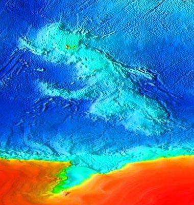
| Description |
Topographical map of the submerged Kerguelen continent. |
|||
|---|---|---|---|---|
| Source |
Source: [1]. Cropped from Image:Elevation.jpg. |
|||
| Date |
14:45, 10 May 2007 (UTC) |
|||
| Author | ||||
| Permission (Reusing this image) |
|
Historique du fichier
Cliquer sur une date et une heure pour voir le fichier tel qu’il était à ce moment-là
| Date et heure | Dimensions | Utilisateur | Commentaire | |
|---|---|---|---|---|
| actuel | 10 mai 2007 à 17:03 | 380×400 (37 Kio) | Wiz9999 | |
| 10 mai 2007 à 16:45 | 4 320×2 160 (1,86 Mio) | Wiz9999 | ({{Information |Description=Topographical map of the submerged Kerguelen continent. |Source=Source: [http://www.ngdc.noaa.gov/mgg/image/2minrelief.html]. Cropped from Image:Elevation.jpg. |Date=~~~~~ |Author=~~~ |Permission={{) |
Pages contenant l’image
Les pages ci-dessous contiennent cette image :

