Image:Is-wb-gs-gh v3.png
Un article de Wikipédia, l'encyclopédie libre.
Taille de cet aperçu : 374 × 600 pixels
Image en plus haute résolution (1 428 × 2 289 pixels, taille du fichier : 259 Kio, type MIME : image/png)
| | Ce fichier provient de Wikimedia Commons?. Les informations le concernant sont affichées ci-dessous (procédure). |
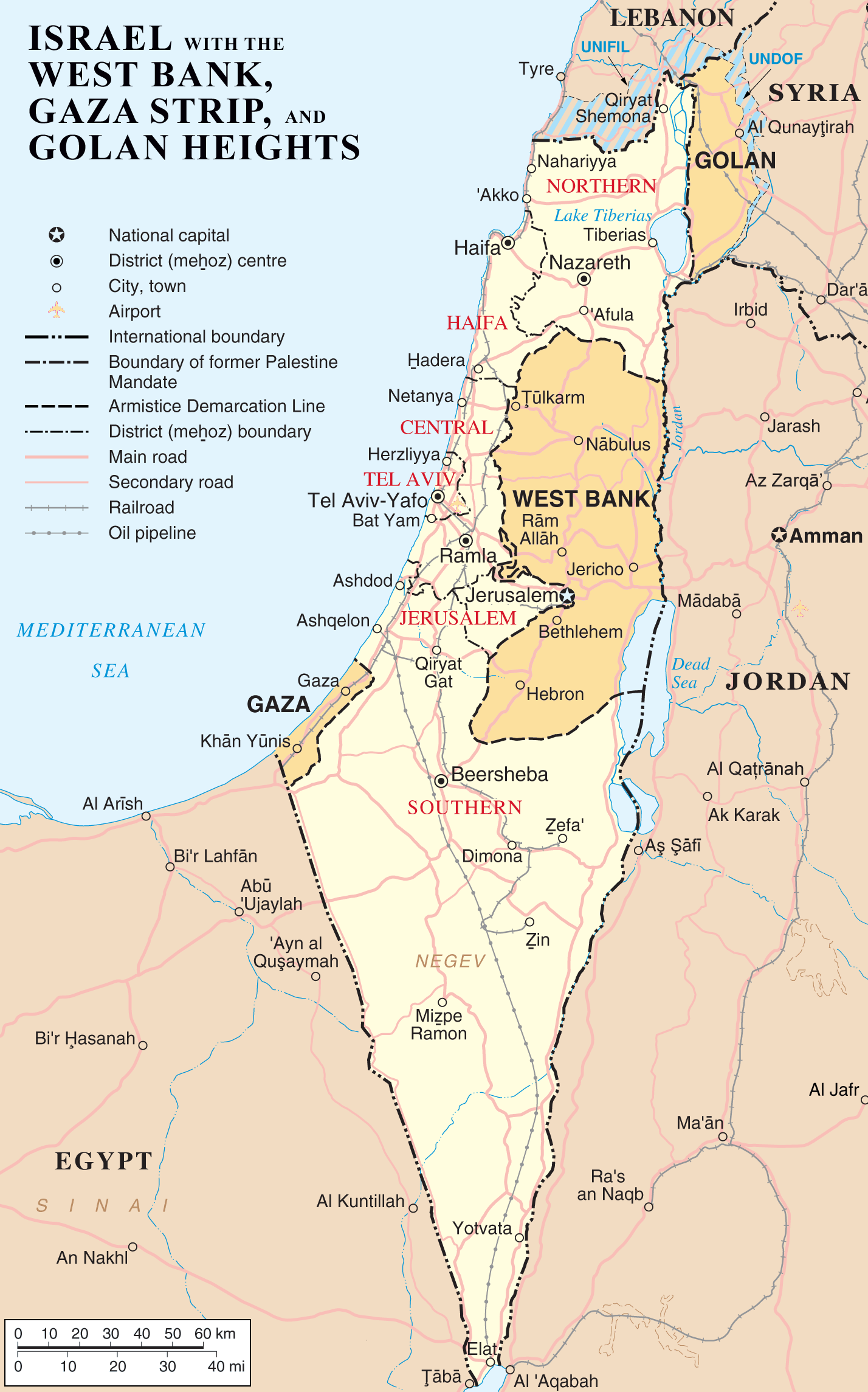
{{Information |Description=Map of Israel, the Palestinian territories (West Bank and Gaza Strip), the Golan Heights, and portions of neighbouring countries. Also United Nations deployment areas in countries adjoining Israel or Israeli-held territory, as of January 2004. |Source=Originally from en.wikipedia; description page is/was here.
(Original text : http://www.un.org/Depts/Cartographic/map/profile/israel.pdf (heavily modified)) |Date=2007-04-03 (original upload date)
(Original text : 3 April 2007) |Author=Original uploader was ChrisO at en.wikipedia
(Original text : [[:en:User:ChrisO) |Permission=Released into the public domain (by the author). |other_versions= }}
[edit] License information
| This image has been (or is hereby) released into the public domain by its author, ChrisO at the wikipedia project. This applies worldwide. In case this is not legally possible: |
| This image is a mapping derived from products of the United Nations Cartographic Section. Modified versions of UNCS maps may be used provided that the UN name and reference number does not appear on any modified version and a link to the original map is provided. Modified UN maps are to be considered in the public domain. This applies worldwide The UN maps is an open source material. You can use them to make your own maps. You do not need our permission for that. Please be advised that the UN name and reference number should not appear on any modified map. The UN map is a UN document and cannot be modified. You can say something like "Based on UN map number..." -- Vladimir Bessarabov (UNCS Cartographer), 13 April 05 |
 |
[edit] Original upload log
(All user names refer to en.wikipedia)
- 2007-04-03 22:53 ChrisO 1428×2289×8 (264824 bytes) == Summary == {{Information |Description= {{en|Map of [[Israel]], the [http://en.wikipedia.org/wiki/Palestinian_territories Palestinian territories] ([[West Bank]] and [[Gaza Strip]]), the [[Golan Heights]], and portions of neighbouring countries. Also [[
Historique du fichier
Cliquer sur une date et une heure pour voir le fichier tel qu’il était à ce moment-là
| Date et heure | Dimensions | Utilisateur | Commentaire | |
|---|---|---|---|---|
| actuel | 11 avril 2007 à 10:22 | 1 428×2 289 (259 Kio) | Liftarn | ({{Information |Description=Map of Israel, the Palestinian territories (West Bank and Gaza Strip), the Golan Heights, and portions of neighbouring countries. Also United Nations deployment areas in countries adjoining Israel or Israeli-held territory, as o) |
Pages contenant l’image
Les pages ci-dessous contiennent cette image :

