Image:Indian Jews communities map-fr.png
Un article de Wikipédia, l'encyclopédie libre.
Pas de plus haute résolution disponible.
Indian_Jews_communities_map-fr.png (328 × 352 pixels, taille du fichier : 45 Kio, type MIME : image/png)
| | Ce fichier provient de Wikimedia Commons?. Les informations le concernant sont affichées ci-dessous (procédure). |
[edit] Summary
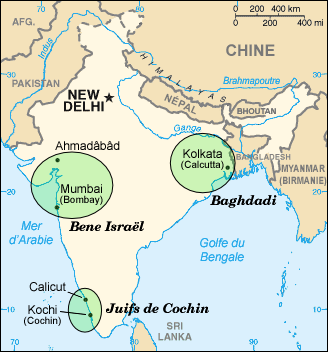
| Description |
Map in French of Jewish communities in India before their emigration to Israel |
|---|---|
| Source |
Background map : Image:Inde_carte.png from the CIA World Factbook (modified) |
| Date |
September 2006 |
| Author |
Eric Gaba (Sting) |
| Permission (Reusing this image) |
GFDL |
| Other versions | in English : Image:Indian_Jews_communities_map.png in German : Image:Indian_Jews_communities_map-de.png |
Français :
- Sujet : Carte en français des communautés juives de l'Inde avant leur émigration vers Israël ;
- 'Sources :
-
- Fond de carte : Image:Inde_carte.png du CIA World Factbook (modifiée) ;
- Données : Image:Map_India_jews_communities_fr.jpg créée par Christophe cagé
- Autre version :
-
- anglophone : Image:Indian_Jews_communities_map.png ;
- germanophone : Image:Indian_Jews_communities_map-de.png ;
- Auteur : Eric Gaba (fr:Sting);
- Date : Septembre 2006.
English: This map was made or improved by the Wikigraphists of the Atelier graphique. You can propose maps or images to clean up and improve as well.
Esperanto: Ĉi tiu mapo estis kreita aŭ plibonigita de la Vikigrafistoj el la Grafika laborgrupo. Vi ankaŭ povas tie proponi mapojn aŭ bildojn plibonigendajn.
Español: Este mapa ha sido confeccionado o mejorado por los Wikígrafos del Taller gráfico. Puedes proponer la mejora de cualquier imagen a través de la página de Peticiones.
Français : Cette carte a été créée ou améliorée par les Wikigraphistes de l'Atelier graphique. Vous pouvez également y proposer des cartes ou des images à améliorer.
Türkçe: Bu harita Atelier graphique'ten Wikigraphistes'ler tarafından yapıldı veya geliştirildi. Siz de haritalar veya resimleri temizlemek veya geliştirmek için teklif edebilirsiniz.
[edit] Licensing

Historique du fichier
Cliquer sur une date et une heure pour voir le fichier tel qu’il était à ce moment-là
| Date et heure | Dimensions | Utilisateur | Commentaire | |
|---|---|---|---|---|
| actuel | 23 septembre 2006 à 05:37 | 328×352 (45 Kio) | Sting | (+ Myanmar) |
| 23 septembre 2006 à 04:48 | 328×352 (44 Kio) | Sting | ({{Information |Description=Map in French of Jewish communities in India before their emigration to Israel |Source='''Background map :''' Image:Inde_carte.png from the CIA World Factbook (modified)<br/>'''Data :''' [[:Image:Map_India_jews_communities_) |
Pages contenant l’image
Les pages ci-dessous contiennent cette image :

