Image:Iles Eparses-CIA WFB Map.png
Un article de Wikipédia, l'encyclopédie libre.
Taille de cet aperçu : 468 × 600 pixels
Image en plus haute résolution (569 × 729 pixels, taille du fichier : 27 Kio, type MIME : image/png)
| | Ce fichier provient de Wikimedia Commons?. Les informations le concernant sont affichées ci-dessous (procédure). |
[edit] Summary
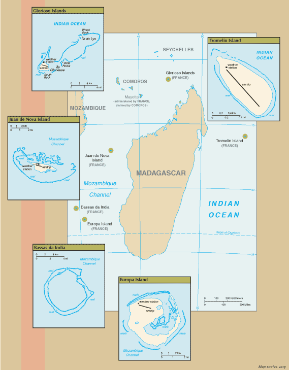
New map of Iles Eparses from 7 Sept 06 rev. of the World Factbook: https://www.cia.gov/cia/publications/factbook/geos/zz.html
[edit] Licensing
| This image is in the public domain because it contains materials that originally came from the United States Central Intelligence Agency's World Factbook.
Deutsch | English | Español | Français | 日本語 | Nederlands | 한국어 | Português | தமிழ் | Magyar | +/- |
 |
Historique du fichier
Cliquer sur une date et une heure pour voir le fichier tel qu’il était à ce moment-là
| Date et heure | Dimensions | Utilisateur | Commentaire | |
|---|---|---|---|---|
| actuel | 8 septembre 2006 à 18:07 | 569×729 (27 Kio) | Hoshie | (==Summary== New map of Iles Eparses from 7 Sept 06 rev. of the World Factbook: [https://www.cia.gov/cia/publications/factbook/geos/zz.html https://www.cia.gov/cia/publications/factbook/geos/zz.html] ==Licensing== {{PD-USGov-CIA-WF}} ) |
Pages contenant l’image
La page ci-dessous contient cette image :

