Image:Himalayas.jpg
Un article de Wikipédia, l'encyclopédie libre.
Taille de cet aperçu : 800 × 530 pixels
Image en plus haute résolution (1 000 × 662 pixels, taille du fichier : 258 Kio, type MIME : image/jpeg)
| | Ce fichier provient de Wikimedia Commons?. Les informations le concernant sont affichées ci-dessous (procédure). |
|
|
This is a featured picture on Wikimedia Commons: it is considered one of our finest images. This is a featured picture on English Wikipedia and is considered one of the finest images. If you have an image of similar quality that can be published under a suitable copyright license, be sure to upload it, tag it, and nominate it. |
| Description |
Deutsch: Der Himalaya von oben gesehen
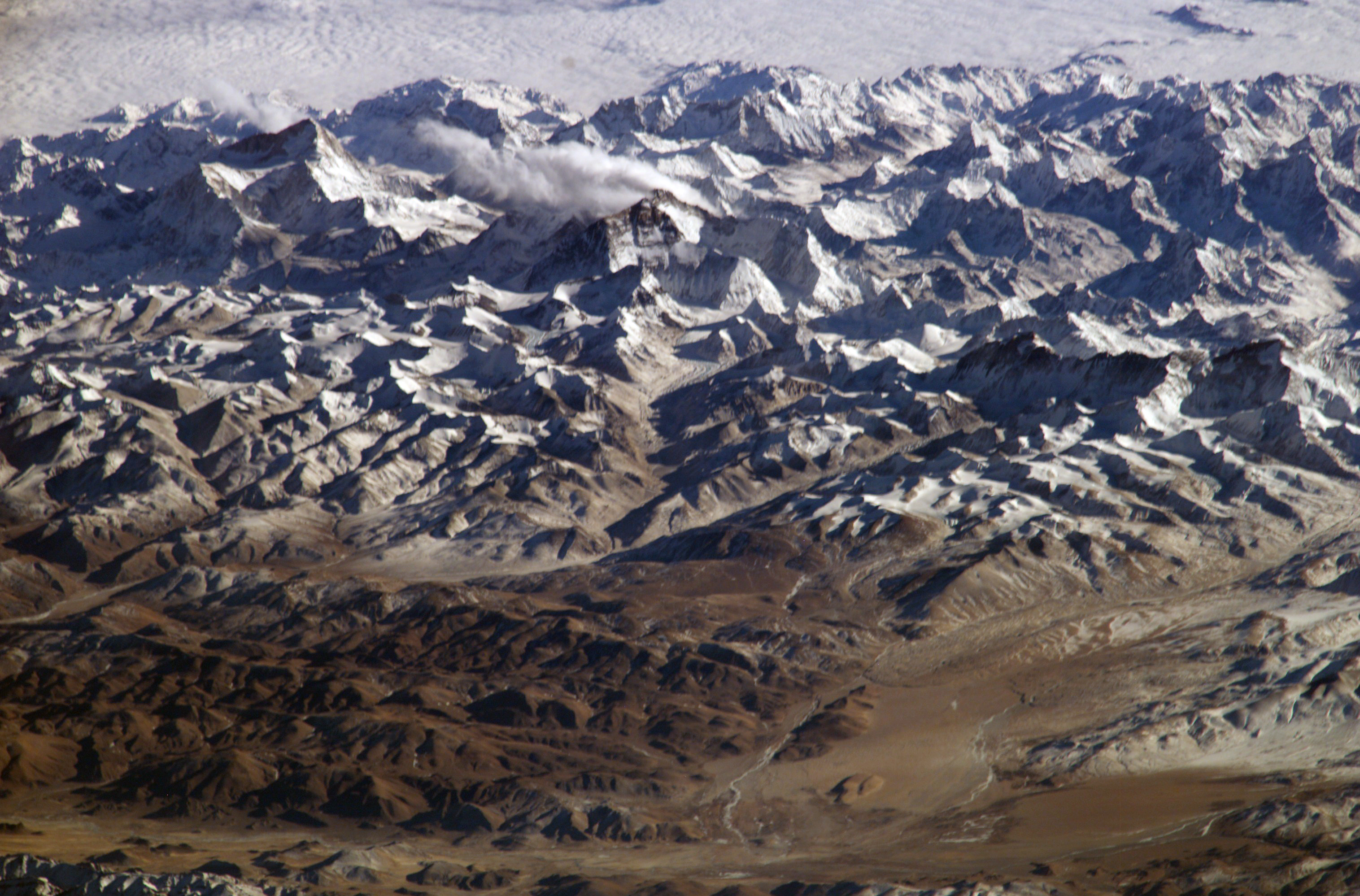
English: Himalaya from the International Space Station. In addition to looking heavenward, NASA helps the world see the Earth in ways no one else can. Astronauts on board the International Space Station recently took advantage of their unique vantage point to photograph the Himalayas, looking south from over the Tibetan Plateau. The perspective is illustrated by the summits of Makalu [left (8,462 metres; 27,765 feet)], Everest [middle (8,848 metres; 29,035 feet)] , Lhotse [middle (8,516 metres; 27,939 feet)] and Cho Oyu [right (8,201 metres; 26,906 feet)] -- at the heights typically flown by commercial aircraft.
Français : L'Himalaya vu de la Station spatiale internationale. La NASA ne fait pas que regarder les étoile, mais utilise aussi ses points de vues uniques pour observer la terre. Cette vue de l'himalaya a été prise depuis la station spatiale internationale, avec le plateau tibétain au premier plan. On peut voir les sommets du Makalu (8 462 mètres, à gauche), de l'Everest (8 848 m, au milieu), du Lhotse (juste a droite de l'Everest, 8516 m) et du Cho Oyu (tout à droite, 8 201 m d'altitude). L'altitude de ces sommets correspond aux altitudes de vol des avions de ligne.
Suomi: Himalaja kansainväliseltä avaruusasemalta kuvattuna
日本語: 国際宇宙ステーションから撮影したヒマラヤ山脈。チベット高原から南方を見た時の図。エベレストが中央付近に見える。
Italiano: L'Himalaya fotografata dalla stazione spaziale internazionale, con l'altopiano del Tibet in primo piano. Si possono notare le cime dei monti Makalu (8462 metri, in alto a sinistra), Everest (8848 metri, in centro), Lhotse (8516 metri, appena sopra l'Everest sulla foto) e Cho Oyu (8201 metri, a destra). Queste altezze corrispondono a quelle raggiunte dagli aerei di linea.
|
|||||
|---|---|---|---|---|---|---|
| Source |
http://www.nasa.gov/multimedia/imagegallery/image_feature_152.html
|
|||||
| Date | ||||||
| Author |
NASA |
|||||
| Permission (Reusing this image) |
|
|||||
| Other versions |

|

| This image or video was catalogued by one of the centers of the United States National Aeronautics and Space Administration (NASA) under Photo ID: ISS008-E-13304. This tag does not indicate the copyright status of the attached work. A normal copyright tag is still required. See Commons:Licensing for more information. |
| This image was selected as a picture of the day for September 16, 2005. It was captioned as followed:
Brezhoneg : Pladenn Tibet (war an araog) hag an Himalaya gwelet eus ar (Savlec'h Egorel Etrebroadel (ISS)
Cymraeg: Mynyddoedd yr Himalayas, o'r Stesion Gofod Rhwngwladol.
|
Historique du fichier
Cliquer sur une date et une heure pour voir le fichier tel qu’il était à ce moment-là
| Date et heure | Dimensions | Utilisateur | Commentaire | |
|---|---|---|---|---|
| actuel | 19 février 2005 à 20:49 | 1 000×662 (258 Kio) | RedWolf | (Himalaya from the ISS. Photo by NASA.) |

