Image:Harz map.png
Un article de Wikipédia, l'encyclopédie libre.
Taille de cet aperçu : 800 × 482 pixels
Image en plus haute résolution (2 529 × 1 523 pixels, taille du fichier : 3,15 Mio, type MIME : image/png)
| | Ce fichier provient de Wikimedia Commons?. Les informations le concernant sont affichées ci-dessous (procédure). |
| Description |
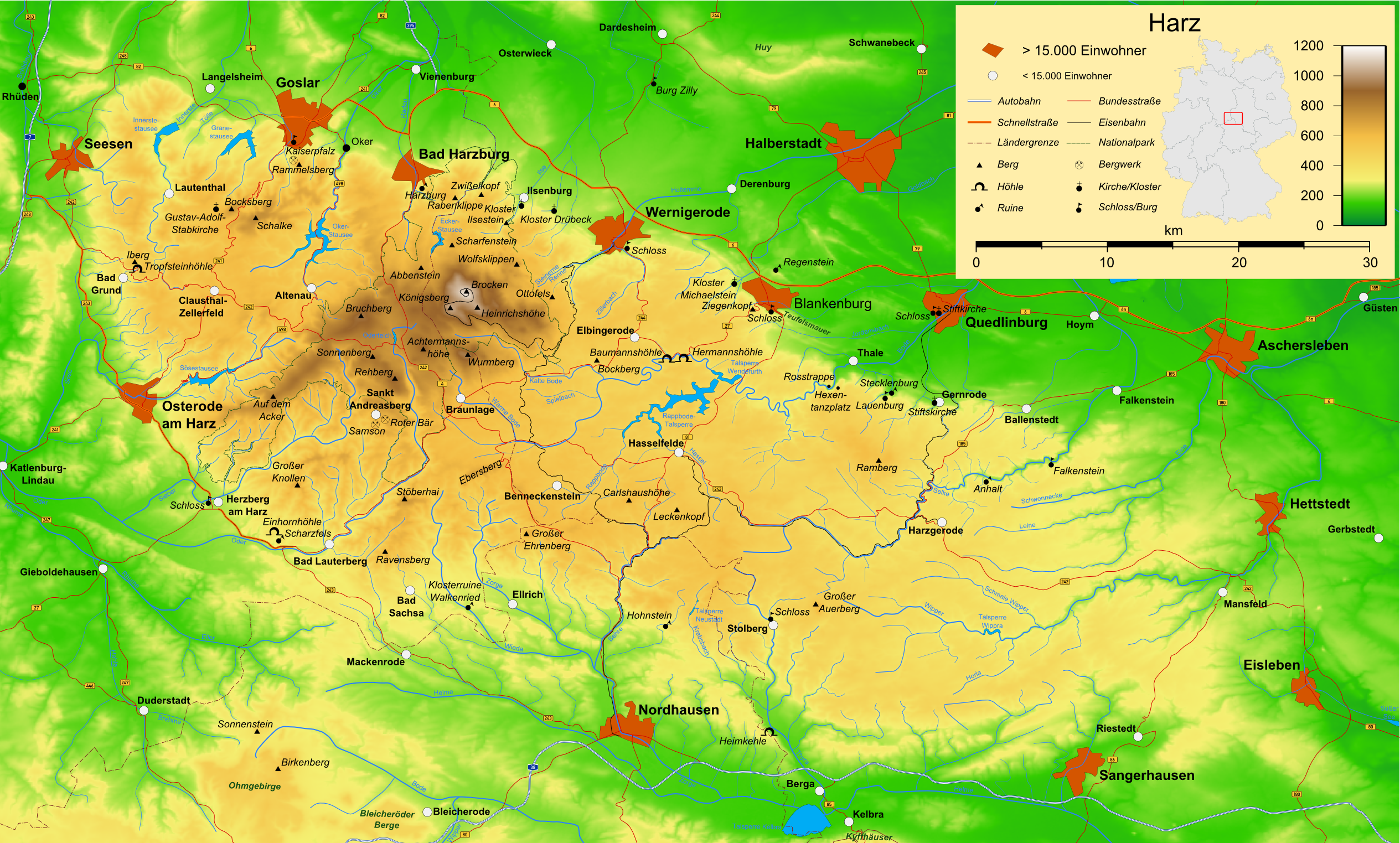
Map of the Harz mountains in Germany with mountains, rivers, lakes, reservoirs, all highways, all Bundesstraßen, Harzquerbahn, Brockenbahn, Selketalbahn, major towns and sights. |
|---|---|
| Source |
self-made |
| Date |
19-09-2007 |
| Author | |
| Permission (Reusing this image) |
see below |
| Other versions |  , ,  , ,  |
 |
Permission is granted to copy, distribute and/or modify this map under the terms of the GNU Free Documentation License, Version 1.2 or any later version published by the Free Software Foundation; with no Invariant Sections, no Front-Cover Texts, and no Back-Cover Texts. A copy of the license is included in the section entitled "GNU Free Documentation License". The map has been created with the Generic Mapping Tools: http://gmt.soest.hawaii.edu/ using one or more of these public domain datasets for the relief:
|
|

Deutsch: Diese Karte wurde in der Kartenwerkstatt erstellt oder verbessert. Auch du kannst uns verbesserungswürdige Karten vorschlagen.
English: This map has been made or improved in the German Kartenwerkstatt (Map Lab). You can propose maps to improve as well.
Français : Cette carte a été créée ou améliorée dans le Kartenwerkstatt (Atelier cartographique) allemand. Vous pouvez également y proposer des cartes à améliorer.
Italiano: Questa carta è stata prodotta e/o migliorata nella tedesca Kartenwerkstatt (Officine per le carte). Anche Tu puoi proporre carte degne di miglioramento.
Русский: Эта карта была улучшена в немецкой Kartenwerkstatt. Вы можете также предложить другие карты для улучшения.
Historique du fichier
Cliquer sur une date et une heure pour voir le fichier tel qu’il était à ce moment-là
| Date et heure | Dimensions | Utilisateur | Commentaire | |
|---|---|---|---|---|
| actuel | 14 décembre 2007 à 08:12 | 2 529×1 523 (3,15 Mio) | Bamse | ({{Information |Description=Map of the Harz mountains in Germany with mountains, rivers, lakes, reservoirs, all highways, all Bundesstraßen, Harzquerbahn, Brockenbahn, [[:w:Selketalba) |
| 19 septembre 2007 à 07:10 | 2 529×1 523 (3,14 Mio) | Bamse | ||
| 19 septembre 2007 à 04:33 | 2 529×1 523 (3,13 Mio) | Bamse | ({{Information |Description=Map of the w:Harz mountains in Germany. |Source=self-made |Date=19-09-2007 |Author= Bamse }} {{GFDL-GMT}} ) | |
| 5 septembre 2007 à 10:21 | 2 529×1 523 (3,09 Mio) | Bamse | ({{Information |Description=Map of the w:Harz mountains in Germany. |Source=self-made |Date=05-09-2007 |Author= Bamse }} {{GFDL-GMT}} ) | |
| 25 juillet 2007 à 08:02 | 2 532×1 527 (3 Mio) | Bamse | ({{Information |Description=Map of the w:Harz mountains in Germany. |Source=self-made |Date=25-07-2007 |Author= Bamse }} {{GFDL-GMT}} ) | |
| 17 juillet 2007 à 12:30 | 2 529×1 526 (2,94 Mio) | Bamse | ({{Information |Description=Map of the w:Harz mountains in Germany. |Source=self-made |Date=17-07-2007 |Author= Bamse }} {{GFDL-GMT}} ) | |
| 11 juillet 2007 à 13:42 | 2 529×1 523 (2,89 Mio) | Bamse | ({{Information |Description=Map of the w:Harz mountains in Germany. |Source=self-made |Date=11-07-2007 |Author= Bamse }} {{GFDL-GMT}} ) | |
| 6 juillet 2007 à 12:21 | 2 529×1 523 (2,84 Mio) | Bamse | ({{Information |Description=Map of the w:Harz mountains in Germany. |Source=self-made |Date=06-07-2007 |Author= Bamse }} {{GFDL-GMT}} ) | |
| 28 juin 2007 à 04:48 | 2 529×1 523 (2,77 Mio) | Bamse | ({{Information |Description=Map of the w:Harz mountains in Germany. |Source=self-made |Date=28-06-2007 |Author= Bamse }} {{GFDL-GMT}} ) | |
| 26 juin 2007 à 04:16 | 2 529×1 523 (2,61 Mio) | Bamse | ({{Information |Description=Map of the w:Harz mountains in Germany. |Source=self-made |Date=21-06-2007 |Author= Bamse }} {{GFDL-GMT}} ) | |
| 21 juin 2007 à 03:55 | 2 531×1 500 (2,38 Mio) | Bamse | ({{Information |Description=Map of the w:Harz mountains in Germany. |Source=self-made |Date=21-06-2007 |Author= Bamse }} {{GFDL-GMT}}) |
Pages contenant l’image
La page ci-dessous contient cette image :

