Image:Gz-map.png
Un article de Wikipédia, l'encyclopédie libre.
Pas de plus haute résolution disponible.
Gz-map.png (328 × 352 pixels, taille du fichier : 8 Kio, type MIME : image/png)
| | Ce fichier provient de Wikimedia Commons?. Les informations le concernant sont affichées ci-dessous (procédure). |
| Description |
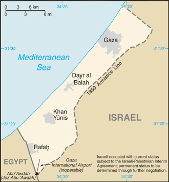
This image was copied from en.wikipedia.org. The original description was: A map of the Gaza Strip showing key towns and neighbouring countries. |
|---|---|
| Source |
Gaza Strip from CIA factbook |
| Date | |
| Author |
Taken from CIA World Factbook website on 15 August. |
| Permission (Reusing this image) |
Public domain, as is all content from the CIA factbook. |
| Other versions | Norsk tekst |
| This image is in the public domain because it contains materials that originally came from the United States Central Intelligence Agency's World Factbook.
Deutsch | English | Español | Français | 日本語 | Nederlands | 한국어 | Português | தமிழ் | Magyar | +/- |
 |
Historique du fichier
Cliquer sur une date et une heure pour voir le fichier tel qu’il était à ce moment-là
| Date et heure | Dimensions | Utilisateur | Commentaire | |
|---|---|---|---|---|
| actuel | 2 décembre 2007 à 04:17 | 328×352 (8 Kio) | Kordas | (Updated map) |
| 15 août 2005 à 20:12 | 328×352 (10 Kio) | Mrmiscellanious | (A map of the Gaza Strip showing key towns and neighbouring countries. Taken from CIA World Factbook website on 15 August 2005. Public domain, as is all content from the CIA factbook.) | |
| 15 septembre 2004 à 14:37 | 330×355 (9 Kio) | Robbot | (This image was copied from en.wikipedia.org. The original description was: A map of the Gaza Strip showing key towns and neighbouring countries. Taken from CIA World Factbook website on 12 April. Public domain, as is all content from ) |
Pages contenant l’image
Les pages ci-dessous contiennent cette image :

