Image:Germany1941.png
Un article de Wikipédia, l'encyclopédie libre.
Pas de plus haute résolution disponible.
Germany1941.png (698 × 600 pixels, taille du fichier : 274 Kio, type MIME : image/png)
| | Ce fichier provient de Wikimedia Commons?. Les informations le concernant sont affichées ci-dessous (procédure). |
| Description |
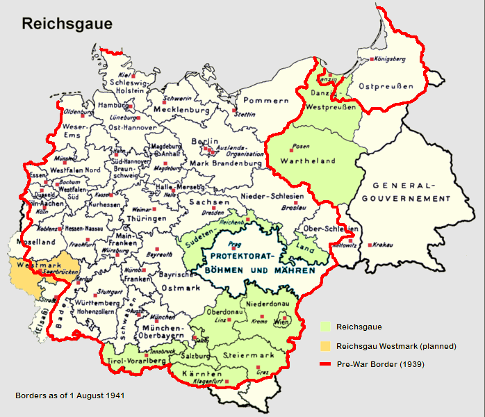
English: Reichsgaue and Generalgouvernement in June 1941
Deutsch: Reichsgaue und Generalgouvernement im Jahre 1941.
Français : La Pologne démembrée dans l'Europe allemande.
Polski: Aneksje III Rzeszy w czasie II wojny światowej (do sierpnia 1941), linia czerwona pokazuje przebieg granicy państwowej Rzeszy 1 września 1939 (wyodrębnione również Wolne Miasto Gdańsk). Aneksje terytorialne III Rzeszy do sierpnia 1941,linia czerwona - przebieg granicy państwowej Niemiec 1 września 1939. Wyodrębniony teren Generalnego Gubernatorstwa. III Rzesza oraz terytoria anektowane i Generalne Gubernatorstwo w sierpniu 1941, linia czerwona pokazuje przebieg granicy Niemiec 1 września 1939. Aneksje III Rzeszy w czasie II wojny światowej (do sierpnia 1941), linia czerwona pokazuje przebieg granicy państwowej Rzeszy 1 września 1939 (wyodrębnione również Wolne Miasto Gdańsk).
Italiano: Il Reichsgau e il Governatorato Generale nel 1941.
Nederlands: Reichsgaue en het Gouvernement-Generaal in 1941.
Español: Mapa de Alemania en 1941, sobre el este (derecha del mapa) el Gobierno General.
中文: Map of the Reichsgaue in 1941.
Norsk (bokmål): Kart over Reichsgau i 1941.
Česky: Generální gouvernement na mapě Třetí říše.
Tiếng Việt: Nước Đức năm 1941, bao gồm lãnh thổ của Ba Lan bị chiếm đóng.
|
|---|---|
| Source |
|
| Date | |
| Author | |
| Permission (Reusing this image) |
see below |
| Other versions | de:Bild:Reichsgaue.png |
[edit] Licensing

Historique du fichier
Cliquer sur une date et une heure pour voir le fichier tel qu’il était à ce moment-là
| Date et heure | Dimensions | Utilisateur | Commentaire | |
|---|---|---|---|---|
| actuel | 6 septembre 2006 à 17:52 | 698×600 (274 Kio) | Ernalve | (Map of Germany in 1941 - Mapa de Alemania en 1941 GFDL from from [http://en.wikipedia.org/wiki/Image:Germany1941.png] Licencia GFDL, tomado de [http://en.wikipedia.org/wiki/Image:Germany1941.png].) |
Pages contenant l’image
La page ci-dessous contient cette image :

