Image:French Guiana CIA.gif
Un article de Wikipédia, l'encyclopédie libre.
Pas de plus haute résolution disponible.
French_Guiana_CIA.gif (330 × 355 pixels, taille du fichier : 8 Kio, type MIME : image/gif)
| | Ce fichier provient de Wikimedia Commons?. Les informations le concernant sont affichées ci-dessous (procédure). |
[edit] Sumary
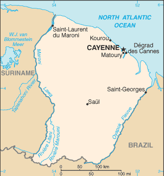
Map of French Guiana taken from the CIA World Factbook web site on December 22, 2005.
[edit] Licensing This image is a map or flag taken and/or modified from the Central Intelligence Agency's World Factbook. Under United States copyright law, all information and images from the World Factbook are in the public domain Subject to disclaimers.
File history Legend: (cur) = this is the current file, (del) = delete this old version, (rev) = revert to this old version. Click on date to download the file or see the image uploaded on that date.
(del) (cur) 22:31, 22 December 2005 . . Eric Shalov (Talk) . . 330x355 (8264 bytes) (== Summary == Map of French Guiana taken from the CIA World Factbook web site on December 22, 2005.)
[edit] Licensing
| This work is in the public domain in the United States because it is a work of the United States Federal Government under the terms of Title 17, Chapter 1, Section 105 of the US Code. See Copyright.
Note: This only applies to works of the Federal Government and not to the work of any individual U.S. state, territory, commonwealth, county, municipality, or any other subdivision. العربية | Български | Česky | Deutsch | English | Español | Français | Magyar | Italiano | 日本語 | 한국어 | Polski | Português | 中文(繁體) | 中文(简体) | +/- |
 |
Historique du fichier
Cliquer sur une date et une heure pour voir le fichier tel qu’il était à ce moment-là
| Date et heure | Dimensions | Utilisateur | Commentaire | |
|---|---|---|---|---|
| actuel | 3 janvier 2006 à 01:01 | 330×355 (8 Kio) | Walden69 | (Map of French Guiana taken from the CIA World Factbook web site on December 22, 2005. [edit] Licensing This image is a map or flag taken and/or modified from the Central Intelligence Agency's World Factbook. Under United States copyright law, all informa) |
Pages contenant l’image
Les pages ci-dessous contiennent cette image :

