Image:Flores map.png
Un article de Wikipédia, l'encyclopédie libre.
Pas de plus haute résolution disponible.
Flores_map.png (300 × 122 pixels, taille du fichier : 21 Kio, type MIME : image/png)
| | Ce fichier provient de Wikimedia Commons?. Les informations le concernant sont affichées ci-dessous (procédure). |
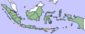
This image was copied from wikipedia:en. The original description was:
Map showing Flores Island within Indonesia
| This file has been released into the public domain by the copyright holder, its copyright has expired, or it is ineligible for copyright. This applies worldwide. | |
Note: This tag is obsolete! Nothing is public domain without a reason. Don't use this generic template - please use instead:
العربية | Български | Česky | Deutsch | English | Español | Français | हिन्दी | Italiano | 日本語 | Norsk (bokmål) | Norsk (nynorsk) | Português | Русский | Slovenčina | Slovenščina | Српски / Srpski | Polski | Türkçe | 中文 | +/- |
| date/time | username | edit summary |
|---|---|---|
| 14:17, 14 March 2005 | *drew | (Map showing Flores Island within Indonesia {{PD}}) |
Historique du fichier
Cliquer sur une date et une heure pour voir le fichier tel qu’il était à ce moment-là
| Date et heure | Dimensions | Utilisateur | Commentaire | |
|---|---|---|---|---|
| actuel | 2 février 2007 à 12:19 | 300×122 (21 Kio) | J. Patrick Fischer | (The original image was copied from wikipedia:en. The image was corrected by user:J. Patrick Fischer (two islands east of Flores were wrong marked as part of Flores before). The original description was: Map showing Flores Island within Indonesia {{) |
| 10 octobre 2006 à 14:26 | 300×122 (16 Kio) | UtherSRG | (Change color.) | |
| 5 octobre 2005 à 14:27 | 300×122 (15 Kio) | ChongDae | (This image was copied from wikipedia:en. The original description was: Map showing Flores Island within Indonesia {{PD}} {| border="1" ! date/time || username || edit summary |---- | 14:17, 14 March 2005 || *drew || <nowiki>(Map showing Flores Island wi) |
Pages contenant l’image
La page ci-dessous contient cette image :

