Image:ElectoralCollege1984-Large.png
Un article de Wikipédia, l'encyclopédie libre.
Taille de cet aperçu : 800 × 430 pixels
Image en plus haute résolution (1 182 × 635 pixels, taille du fichier : 163 Kio, type MIME : image/png)
| | Ce fichier provient de Wikimedia Commons?. Les informations le concernant sont affichées ci-dessous (procédure). |
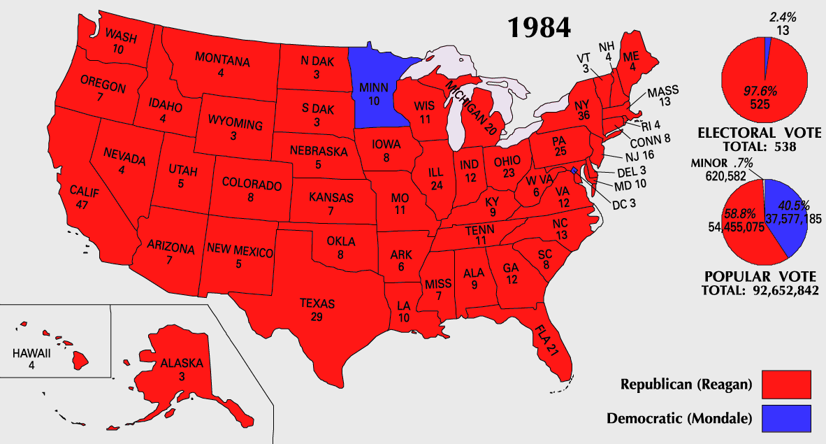
| This map was obtained from an edition of the National Atlas of the United States. Like almost all works of the U.S. federal government, works from the National Atlas are in the public domain. Online access: NationalAtlas.gov | 1970 print edition: Library of Congress, Perry-Castañeda Library |
|
| US presidential election maps |
| 1789 · 1792 · 1796 · 1800 · 1804 · 1808 · 1812 · 1816 · 1820 · 1824 · 1828 · 1832 · 1836 · 1840 · 1844 · 1848 · 1852 · 1856 · 1860 · 1864 · 1868 · 1872 · 1876 · 1880 · 1884 · 1888 · 1892 · 1896 · 1900 · 1904 · 1908 · 1912 · 1916 · 1920 · 1924 · 1928 · 1932 · 1936 · 1940 · 1944 · 1948 · 1952 · 1956 · 1960 · 1964 · 1968 · 1972 · 1976 · 1980 · 1984 · 1988 · 1992 · 1996 · 2000 · 2004 |
 |
This map image should be recreated using vector graphics as an SVG file. This has several advantages; see Commons:Media for cleanup for more information. If an SVG form of this image is already available, please upload it. After uploading an SVG, replace this template with template {{Vector version available|new image name.svg}} in this image. |
|
العربية | Български | Català | Česky | Dansk | Deutsch | English | Esperanto | Español | Français | 한국어 | Italiano | Magyar | Lietuvių | Nederlands | 日本語 | Polski | Português | Română | Русский | Suomi | Svenska | Türkçe | Українська | Tiếng Việt | मराठी | 中文(繁體) | 中文(简体) | +/- |
|
Historique du fichier
Cliquer sur une date et une heure pour voir le fichier tel qu’il était à ce moment-là
| Date et heure | Dimensions | Utilisateur | Commentaire | |
|---|---|---|---|---|
| actuel | 25 juillet 2007 à 12:20 | 1 182×635 (163 Kio) | Cardsplayer4life | (Reverted to earlier revision) |
| 25 juillet 2007 à 11:32 | 1 182×635 (104 Kio) | Joseph Solis in Australia | ({{PD-USGov-Atlas}} Category:1988 {{US presidential election maps}}) | |
| 9 juillet 2007 à 03:46 | 1 182×635 (163 Kio) | Cardsplayer4life | ({{PD-USGov-Atlas}} Category:1984 {{US presidential election maps}} ) | |
| 6 juillet 2007 à 11:36 | 1 182×635 (104 Kio) | Joseph Solis in Australia | ({{PD-USGov-Atlas}} Category:1984 {{US presidential election maps}}) | |
| 2 juillet 2007 à 04:28 | 1 182×635 (163 Kio) | Cardsplayer4life | ({{PD-USGov-Atlas}} Category:1984 {{US presidential election maps}} ) | |
| 29 juin 2007 à 12:14 | 1 182×635 (104 Kio) | Joseph Solis in Australia | ({{PD-USGov-Atlas}} Category:1984 {{US presidential election maps}}) | |
| 21 juin 2007 à 23:07 | 1 182×635 (163 Kio) | Cardsplayer4life | ({{PD-USGov-Atlas}} Category:1984 {{US presidential election maps}}) | |
| 31 mai 2007 à 10:27 | 1 182×635 (104 Kio) | Joseph Solis in Australia | ({{PD-USGov-Atlas}} Category:1984 {{US presidential election maps}}) | |
| 25 mai 2006 à 22:06 | 1 182×635 (89 Kio) | JP06035 | (switched colors) | |
| 22 janvier 2006 à 18:08 | 1 182×635 (104 Kio) | Red devil 666 | ({{PD-USGov-Atlas}}) |
Pages contenant l’image
Les pages ci-dessous contiennent cette image :

