Image:Eldfell, Helgafell and the fissure.jpg
Un article de Wikipédia, l'encyclopédie libre.
Pas de plus haute résolution disponible.
Eldfell,_Helgafell_and_the_fissure.jpg (450 × 294 pixels, taille du fichier : 47 Kio, type MIME : image/jpeg)
| | Ce fichier provient de Wikimedia Commons?. Les informations le concernant sont affichées ci-dessous (procédure). |
[edit] Summary
| Description |
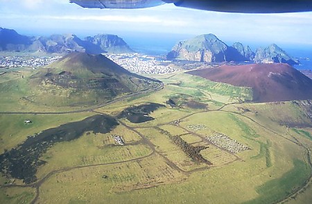
The island of Heimaey, with Helgafell at the left and Eldfell on the right. The extent of the 1973 eruption fissure south of Eldfell is clearly seen. |
|---|---|
| Source |
http://iceland.world-traveller.org iceland.world-traveller.org |
| Date | |
| Author | |
| Permission (Reusing this image) |
GFDL |
[edit] Licensing
 |
Permission is granted to copy, distribute and/or modify this document under the terms of the GNU Free Documentation License, Version 1.2 or any later version published by the Free Software Foundation; with no Invariant Sections, no Front-Cover Texts, and no Back-Cover Texts. Subject to disclaimers. Asturianu | Български | Català | Deutsch | English | Español | Français | Gaeilge | Italiano | 한국어 | 日本語 | Polski | Português | Română | Türkçe | +/- |
Historique du fichier
Cliquer sur une date et une heure pour voir le fichier tel qu’il était à ce moment-là
| Date et heure | Dimensions | Utilisateur | Commentaire | |
|---|---|---|---|---|
| actuel | 11 mai 2006 à 20:22 | 450×294 (47 Kio) | Wirthi | ({{Information| |Description=The island of Heimaey, with Helgafell at the left and Eldfell on the right. The extent of the 1973 eruption fissure south of Eldfell is clearly seen. |Source=http://iceland.world-traveller.org iceland.world-traveller.org |Date=) |
Pages contenant l’image
La page ci-dessous contient cette image :

