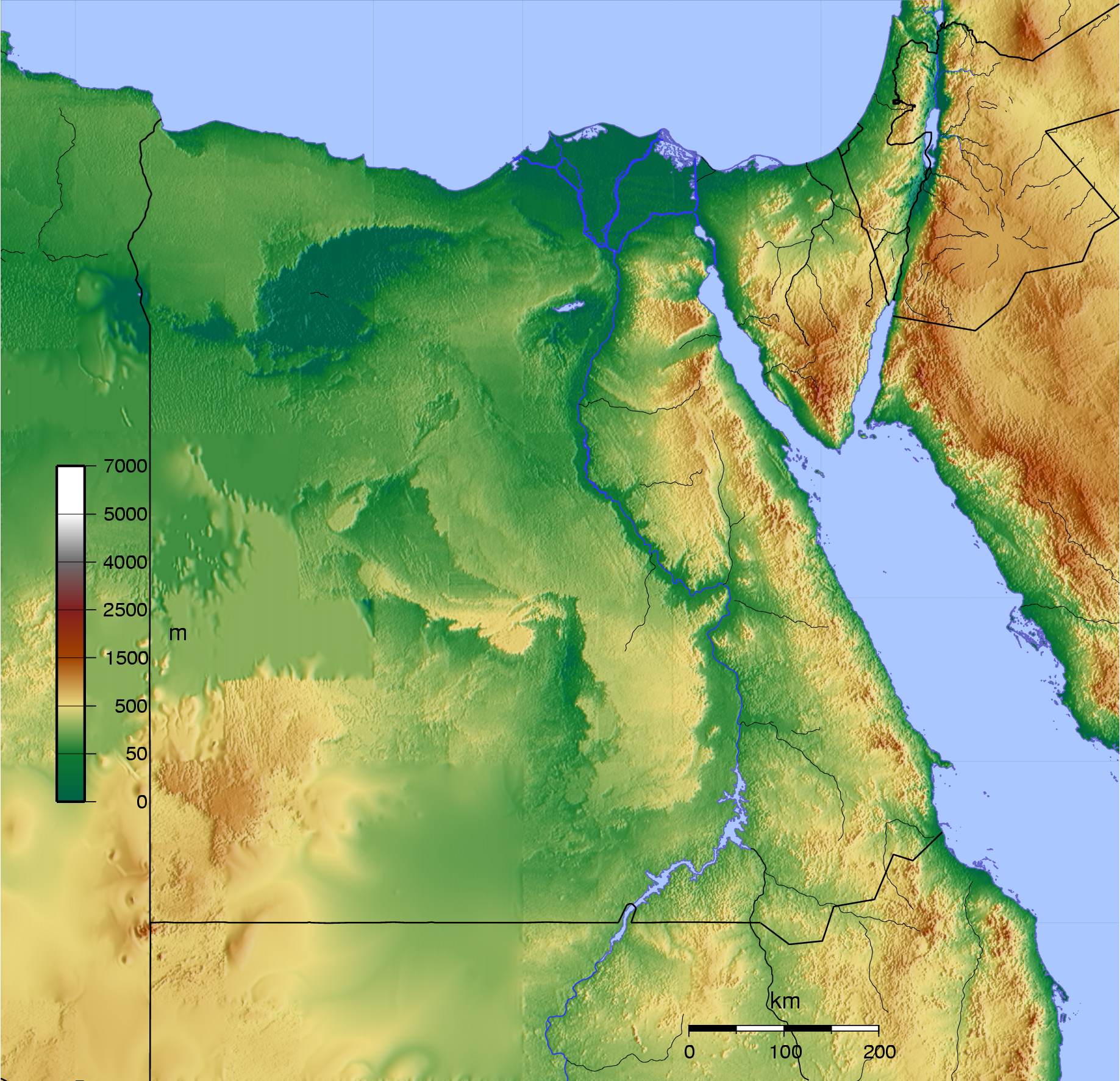
Image:Egypt map topo.png
Un article de Wikipédia, l'encyclopédie libre.
Taille de cet aperçu : 621 × 599 pixels
Image en plus haute résolution (1 837 × 1 773 pixels, taille du fichier : 3,99 Mio, type MIME : image/png)
| | Ce fichier provient de Wikimedia Commons?. Les informations le concernant sont affichées ci-dessous (procédure). |
Copyright © 2005 David Monniaux

| This file is licensed under Creative Commons Attribution ShareAlike 2.0 License (cc-by-sa-2.0). In short: you are free to share and make derivative works of the file under the conditions that you appropriately attribute it, and that you distribute it under this or a similar cc-by-sa license. |
| This file is licenced under the Creative Commons "Attribution ShareAlike 2.0 France" Licence Ce fichier est sous la licence de Creative Commons suivante : |
|
Scripts in public domain. To reconstruct the image, you need:
- the Generic Mapping Tools
- GTOPO30 tile E020N40
- dem2ascii
RFLAG="-R23/38/20/33"
IFLAG=-I30c
GTOPO30=../GTOPO30

dem2ascii $RFLAG $GTOPO30/E020N40 | surface -GEgypt.grd $RFLAG $IFLAG -H0 -S50k
-T0.4 -Z1.2
#!/bin/sh
RFLAG="-R23/38/20/33"
FORMAT=-P
PROJECTION="$RFLAG -JM20 $FORMAT"
#CITY_LAT=48.866667
#CITY_LONG=2.333333
#CITY_NAME=Paris

PALETTE=mountains2.cpt

PSFILE=egypt.ps
PNGFILE=egypt.png

# avant: -Ne.5 comme -N
grdgradient Egypt.grd -Nt.5 -A100 -M -GEgypt_i5.grd
grdimage -Ei -IEgypt_i5.grd -C$PALETTE $PROJECTION Egypt.grd -K > $PSFILE

RIVERS="\
  -I1/0.5p/50/50/255\
  -I2/0.4p/50/50/255\
  -I3/0.3p/50/50/255\
  -I4/0.2p/50/50/255\
  -I5/0.4p,-/50/50/255\
  -I6/0.3p,-/50/50/255\
  -I7/0.2p,-/50/50/255\
  -I8/1p/50/50/255"

SCALE=-Lfx14/1/45/200k

pscoast $PROJECTION\
  -Dh \
  -W0.5p/100/100/200 \
  -N1/0.75p \
  -S170/200/255\
  $BORDER\
  $SCALE\
  $RIVERS\
  -O -K\
  >> $PSFILE

#grdcontour -Csea.contour $PROJECTION -K -O Egypt.grd >> $PSFILE

psscale -D1/8/6/0.5 -C$PALETTE -B:m: -L -O $FORMAT >>$PSFILE

GS_OPTIONS="-dTextAlphaBits=4 -dGraphicsAlphaBits=4"
export GS_OPTIONS
pstopnm -portrait -xsize=2000 -xborder=0 -yborder=0 -stdout -ppm  $PSFILE | pnmt
opng > $PNGFILE
epstopdf $PSFILE
Historique du fichier
Cliquer sur une date et une heure pour voir le fichier tel qu’il était à ce moment-là
| Date et heure | Dimensions | Utilisateur | Commentaire | |
|---|---|---|---|---|
| actuel | 29 mai 2005 à 19:19 | 1 837×1 773 (3,99 Mio) | David.Monniaux | |
| 26 mai 2005 à 19:58 | 2 000×1 773 (4,04 Mio) | David.Monniaux | ({{subst:DMonniaux}}) |
Pages contenant l’image
Les pages ci-dessous contiennent cette image :

