Image:Dry line-Satellite view.jpg
Un article de Wikipédia, l'encyclopédie libre.
Pas de plus haute résolution disponible.
Dry_line-Satellite_view.jpg (500 × 493 pixels, taille du fichier : 152 Kio, type MIME : image/jpeg)
| | Ce fichier provient de Wikimedia Commons?. Les informations le concernant sont affichées ci-dessous (procédure). |
| Description |
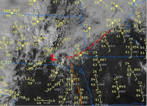
Satellite view in visible range of convection along a Dry line (yellow line) and surface station data showing temperature around 86F in the whole sector but dew points in the 60's east of it and in the 50' West of it. |
|||
|---|---|---|---|---|
| Source |
National Weather Service (NOAA) in a case Study of the Southeast South Dakota Tornadoes of 16 September 2006 |
|||
| Date |
23:52, 18 October 2007 (UTC) |
|||
| Author | ||||
| Permission (Reusing this image) |
|
|||
| Other versions | None |
Historique du fichier
Cliquer sur une date et une heure pour voir le fichier tel qu’il était à ce moment-là
| Date et heure | Dimensions | Utilisateur | Commentaire | |
|---|---|---|---|---|
| actuel | 19 octobre 2007 à 01:52 | 500×493 (152 Kio) | Pierre cb | ({{Information |Description=Satellite view in visible range of convection along a Dry line (yellow line) and surface station data showing temperature around 86F in the whole sector but dew points in the 60's east of it and in the 50' West of it. |Source=[h) |
Pages contenant l’image
La page ci-dessous contient cette image :

