Image:Djibouti districts named.png

Un article de Wikipédia, l'encyclopédie libre.

Ci-dessous, retrouvez page de description du fichier provenant de Commons.
Description

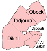
Map of the districts of Djibouti, named in English. Note that as of sometime in 2005 or so, this map was obsolete. The individual maps are:

Source

Self-made, traced from public domain UN or CIA maps.

Date

December 2004

Author

User:Golbez

Permission
(Reusing this image)

Provide attribution, please. See below.


I, the copyright holder of this work, hereby publish it under the following licenses:
Some rights reserved
Creative Commons Attribution iconCreative Commons Share Alike icon
This file is licensed under the Creative Commons Attribution ShareAlike license versions 2.5, 2.0, and 1.0

العربية | Български | Català | Česky | Dansk | Deutsch | English | Español | Euskara | فارسی | Français | עברית | Italiano | 日本語 | 한국어 | Lietuvių | Nederlands | Polski | Português | Русский | Svenska | தமிழ் | Türkçe | 中文 | 中文 | +/-

GNU head Permission is granted to copy, distribute and/or modify this document under the terms of the GNU Free Documentation license, Version 1.2 or any later version published by the Free Software Foundation; with no Invariant Sections, no Front-Cover Texts, and no Back-Cover Texts. A copy of the license is included in the section entitled "GNU Free Documentation license".

Aragonés | العربية | Asturianu | Български | বাংলা | ইমার ঠার/বিষ্ণুপ্রিয়া মণিপুরী | Brezhoneg | Bosanski | Català | Cebuano | Česky | Dansk | Deutsch | Ελληνικά | English | Esperanto | Español | Eesti | Euskara | فارسی | Suomi | Français | Gaeilge | Galego | עברית | Hrvatski | Magyar | Bahasa Indonesia | Ido | Íslenska | Italiano | 日本語 | ქართული | ភាសាខ្មែរ | 한국어 | Kurdî / كوردی | Latina | Lëtzebuergesch | Lietuvių | Bahasa Melayu | Nnapulitano | Nederlands | ‪Norsk (nynorsk)‬ | ‪Norsk (bokmål)‬ | Occitan | Polski | Português | Română | Русский | Slovenčina | Slovenščina | Shqip | Српски / Srpski | Svenska | తెలుగు | ไทย | Türkçe | Українська | اردو | Tiếng Việt | Volapük | Yorùbá | ‪中文(中国大陆)‬ | ‪中文(台灣)‬ | +/-

You may select the license of your choice.

Historique du fichier

Cliquer sur une date et une heure pour voir le fichier tel qu’il était à ce moment-là

Date et heureDimensionsUtilisateurCommentaire
actuel28 décembre 2004 à 21:40150×165 (4 Kio)Golbez (Map of the districts of Djibouti. Made by User:Golbez. {{cc-by-sa-2.0}})

La page ci-dessous contient cette image :