Image:Curonians kursenieki in 1649.png
Un article de Wikipédia, l'encyclopédie libre.
Pas de plus haute résolution disponible.
Curonians_kursenieki_in_1649.png (400 × 400 pixels, taille du fichier : 6 Kio, type MIME : image/png)
| | Ce fichier provient de Wikimedia Commons?. Les informations le concernant sont affichées ci-dessous (procédure). |
[edit] Summary
| Description |
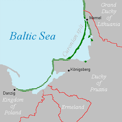
Curonian teritorry in 1649. |
|---|---|
| Source |
Own work, based on map from Kleinlitauen im Herzogtum Preußen (1525-1701) and report: "Es halten sich auch ein gut Theil derselben [t.i. -latviešu] in Preussen auff/ denn dieselben so am Curischen Haie von der Memel und ferner biß fast an Dantzig/ am Wasser wohnen/sind Letten und gebrauchen sich der Lettischen Sprache" [1] |
| Date |
2006-09-04 |
| Author | |
| Permission (Reusing this image) |
see below |
[edit] Licensing
| I, the copyright holder of this work, hereby release it into the public domain. This applies worldwide. In case this is not legally possible: Afrikaans | Alemannisch | Aragonés | العربية | Asturianu | Български | Català | Česky | Cymraeg | Dansk | Deutsch | Eʋegbe | Ελληνικά | English | Español | Esperanto | Euskara | Estremeñu | فارسی | Français | Galego | 한국어 | हिन्दी | Hrvatski | Ido | Bahasa Indonesia | Íslenska | Italiano | עברית | Kurdî / كوردی | Latina | Lietuvių | Latviešu | Magyar | Македонски | Bahasa Melayu | Nederlands | Norsk (bokmål) | Norsk (nynorsk) | 日本語 | Polski | Português | Ripoarisch | Română | Русский | Shqip | Slovenčina | Slovenščina | Српски / Srpski | Svenska | ไทย | Tagalog | Türkçe | Українська | Tiếng Việt | Walon | 中文(简体) | 中文(繁體) | zh-yue-hant | +/- |
 |
This map image should be recreated using vector graphics as an SVG file. This has several advantages; see Commons:Media for cleanup for more information. If an SVG form of this image is already available, please upload it. After uploading an SVG, replace this template with template {{Vector version available|new image name.svg}} in this image. |
|
العربية | Български | Català | Česky | Dansk | Deutsch | English | Esperanto | Español | Français | 한국어 | Italiano | Magyar | Lietuvių | Nederlands | 日本語 | Polski | Português | Română | Русский | Suomi | Svenska | Türkçe | Українська | Tiếng Việt | मराठी | 中文(繁體) | 中文(简体) | +/- |
|
Historique du fichier
Cliquer sur une date et une heure pour voir le fichier tel qu’il était à ce moment-là
| Date et heure | Dimensions | Utilisateur | Commentaire | |
|---|---|---|---|---|
| actuel | 17 décembre 2006 à 18:42 | 400×400 (6 Kio) | Tarakonas | (== Summary == {{Information |Description=Curonian teritorry in 1649. |Source=Own work, based on map from [http://www.istorija.net/kleinlitauen/mazojilietuva16n.htm Kleinlitauen im Herzogtum Preußen (1525-1701)] and report: "Es halten sich auch ein gut Th) |
| 4 septembre 2006 à 20:09 | 400×400 (6 Kio) | Tarakonas | (== Summary == {{Information |Description=curonians' teritorry in 1649 |Source=own work |Date=2006-09-04 |Author=tarakonas |Permission=see below |other_versions=none }}) | |
| 4 septembre 2006 à 20:06 | 400×400 (6 Kio) | Tarakonas | (== Summary == {{Information |Description=curonians' teritorry in 1649 |Source=own work |Date=2006-09-04 |Author=tarakonas |Permission={{PD-self}} |other_versions=none }}) | |
| 14 août 2006 à 19:53 | 400×400 (5 Kio) | Tarakonas | ({{Information |Description=curonians' teritorry in 1649 |Source=own work |Date=2006-08-14 |Author=tarakonas |Permission={{PD-Art}} |other_versions=none }}) |
Pages contenant l’image
La page ci-dessous contient cette image :

