Image:CircumnavigationByCapes.png
Un article de Wikipédia, l'encyclopédie libre.
Pas de plus haute résolution disponible.
CircumnavigationByCapes.png (800 × 500 pixels, taille du fichier : 286 Kio, type MIME : image/png)
| | Ce fichier provient de Wikimedia Commons?. Les informations le concernant sont affichées ci-dessous (procédure). |
[edit] Summary
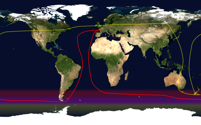
This image shows the route, in red, of a typical round-the-world yacht race via the great capes, by way of the roaring forties. Shown in yellow is the antipodean point of each point on the route; it can be seen that a boat following this route will not pass through any antipodean points. Since doing so in the context of a race — particularly a non-stop race — would be impractical, yacht racing uses a different definition of a circumnavigation.
This image was constructed from a public domain Visible Earth product of the Earth Observatory office of the United States government space agency NASA. It is based on a cylindrical equi-distant projection.
[edit] Licensing
|
|
This file is in the public domain because it was created by NASA. NASA copyright policy states that "NASA material is not protected by copyright unless noted". (NASA copyright policy page or JPL Image Use Policy).
Deutsch | English | Español | Français | Nederlands | Português | Русский | 中文(简体) | 中文(繁體) | +/- |
|
 |
Warnings:
|
Historique du fichier
Cliquer sur une date et une heure pour voir le fichier tel qu’il était à ce moment-là
| Date et heure | Dimensions | Utilisateur | Commentaire | |
|---|---|---|---|---|
| actuel | 23 janvier 2006 à 18:09 | 800×500 (286 Kio) | Johantheghost | (This image shows the route, in red, of a typical round-the-world yacht race via the great capes, by way of the roaring forties. Shown in yellow is the [[Wikipedia:antipodes) |
Pages contenant l’image
La page ci-dessous contient cette image :

