Image:ChiPitts area.png
Un article de Wikipédia, l'encyclopédie libre.
Pas de plus haute résolution disponible.
ChiPitts_area.png (300 × 300 pixels, taille du fichier : 23 Kio, type MIME : image/png)
| | Ce fichier provient de Wikimedia Commons?. Les informations le concernant sont affichées ci-dessous (procédure). |
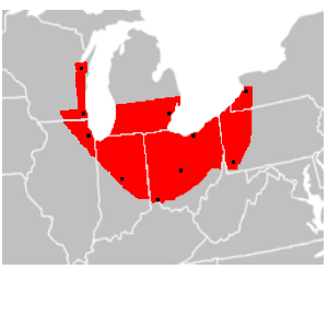
| Description |
en:ChiPitts (Chicago-Pittsburg) megalopolis area in red. Major cities are shown with a black dot |
|---|---|
| Source |
Image made from BlankMap-USA-states.PNG, modified to show approximate boundaries of the ChiPitts |
| Date | |
| Author | |
| Permission (Reusing this image) |
see below |
| Other versions | en:Image:ChiPitts_area.png |
| This image has been (or is hereby) released into the public domain by its author, Ctjf83 at the English Wikipedia project. This applies worldwide. In case this is not legally possible: |
Historique du fichier
Cliquer sur une date et une heure pour voir le fichier tel qu’il était à ce moment-là
| Date et heure | Dimensions | Utilisateur | Commentaire | |
|---|---|---|---|---|
| actuel | 14 mars 2008 à 16:27 | 300×300 (23 Kio) | Pierre cb | ({{Information |Description=en:ChiPitts megalopolis area in red. Major cities are shown with a black dot |Source=Image made from [http://commons.wikimedia.org/wiki/Image:BlankMap-USA-states.PNG BlankMap-USA-states.PNG], modified to show approximate b) |
Pages contenant l’image
La page ci-dessous contient cette image :

