Image:Brazil-16-map.jpg
Un article de Wikipédia, l'encyclopédie libre.
Pas de plus haute résolution disponible.
Brazil-16-map.jpg (379 × 516 pixels, taille du fichier : 277 Kio, type MIME : image/jpeg)
| | Ce fichier provient de Wikimedia Commons?. Les informations le concernant sont affichées ci-dessous (procédure). |
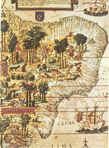
scan from 《社会历史博物馆》 ISBN 7-5347-1397-8
"社会历史博物馆" / "Social Historical Museum"
16世纪巴西的地图 / The map of Brasil in 16th century
1519年葡萄牙人绘制 / Issued in Portugal in 1519
| This image (or other media file) is in the public domain because its copyright has expired. This applies to the United States, Canada, the European Union and those countries with a copyright term of life of the author plus 70 years.
العربية | Asturianu | Български | Català | Česky | Dansk | Deutsch | English | Ελληνικά | Esperanto | Español | Euskara | فارسی | Français | Gaeilge | Galego | עברית | हिन्दी | Bahasa Indonesia | Italiano | 日本語 | 한국어 | Kurdî / كوردی | Lietuvių | Magyar | Nederlands | Norsk (nynorsk) | Македонски | Bahasa Melayu | Polski | Português | Română | Русский | Slovenčina | Slovenščina | Shqip | Suomi | Sámegiella | Türkçe | 中文(简体) | 中文(繁體) | 粵語 | +/- |
[edit] See also

Historique du fichier
Cliquer sur une date et une heure pour voir le fichier tel qu’il était à ce moment-là
| Date et heure | Dimensions | Utilisateur | Commentaire | |
|---|---|---|---|---|
| actuel | 6 juin 2005 à 21:00 | 379×516 (277 Kio) | Shizhao | (scan from 《社会历史博物馆》 ISBN 7-5347-1397-8 16世纪巴西的地图 1519年葡萄牙人绘制 {{PD}}) |
Pages contenant l’image
Les pages ci-dessous contiennent cette image :
- Pierre II du Brésil
- Guerre de la Triple Alliance
- Café com leite
- Coronelismo
- Histoire du Brésil
- Amélie du Brésil
- Amélie de Leuchtenberg
- Auguste de Leuchtenberg
- Estado Novo (Brésil)
- Ordre du Cruzeiro
- République Juliana
- Portail:Brésil
- Portail:Brésil/Histoire
- Révolution fédéraliste
- Brésil hollandais
- Senzala
- Immigration portugaise au Brésil
- Actes institutionnels (Brésil)
- Sambaqui
- Sesmaria
- Guerre du Contestado
- Henri de Coimbra
- Tropeiro
- Joaquim José da Silva Xavier
- Capitainerie (Brésil)
- Conjuration Mineira
- Modèle:Ébauche histoire du Brésil
- Francisco Dias Velho
- Antônio Carlos Ribeiro de Andrada
- Révolution de 1930 (Brésil)
- Colonne Prestes
- José da Silva Paes
- Capitainerie de Santa Catarina
- Capitainerie de São Paulo
- Capitainerie de Santana
- Capitainerie du Rio Grande
- Capitainerie d'Itamaracá
- Révolte de l'Armada
- Capitainerie de São Tomé
- Capitainerie du Ceará
- Capitainerie de Goiás
- Capitainerie d'Ilhéus
- José Pereira Pinto
- Capitainerie d'Alagoas
- Capitainerie de São Pedro do Rio Grande do Sul
- Capitainerie de São Paulo e Minas de Ouro
- Gabriel de Lara
- Conjuration Baiana
- Traité de Petrópolis
- Fort de São Cristóvão
- São Lourenço das Missões
- Luís de Vasconcelos e Sousa (1742-1809)
- Ângelo Moniz da Silva Ferraz
- Fort de Santana do Estreito
- Fort de Santa Bárbara da Vila
- Fort Marechal Moura de Naufragados
- Batterie de São Caetano da Ponta Grossa
- José Luís de Castro
- Luís de Almeida Portugal Soares de Alarcão d'Eça e Melo Silva Mascarenhas
- Marcos de Noronha e Brito
- Fernando José de Portugal e Castro
- Capitainerie du Piauí
- Antônio Rolim de Moura Tavares
- Antônio Álvares da Cunha
- Société de colonisation de Santa Catarina
- Révolution Pernambucana
- Modèle:Ébauche/paramètres histoire du Brésil
- Révolte Paulista
- Conflits de l'Empire (Brésil)
- Conflits de la Période républicaine (Brésil)
- Dictature militaire au Brésil (1964-1985)

