Image:BigSandy watershed.png
Un article de Wikipédia, l'encyclopédie libre.
Pas de plus haute résolution disponible.
BigSandy_watershed.png (288 × 240 pixels, taille du fichier : 70 Kio, type MIME : image/png)
| | Ce fichier provient de Wikimedia Commons?. Les informations le concernant sont affichées ci-dessous (procédure). |
[edit] Summary
| Description |
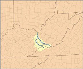
This is a map of the Big Sandy River system, showing its main tributaries, Tug Fork to the east and Levisa Fork to the west. I, Pfly, created it based on USGS data. |
|---|---|
| Source |
Own work. |
| Date |
January 10, 2007 |
| Author | |
| Permission (Reusing this image) |
see below |
[edit] Licensing
|
Historique du fichier
Cliquer sur une date et une heure pour voir le fichier tel qu’il était à ce moment-là
| Date et heure | Dimensions | Utilisateur | Commentaire | |
|---|---|---|---|---|
| actuel | 24 mars 2007 à 03:34 | 288×240 (70 Kio) | DanMS | (Removed excess white space around edges and uploaded again.) |
| 11 janvier 2007 à 00:42 | 300×252 (90 Kio) | Pfly | ({{Information |Description=This is a map of the Big Sandy River system, showing its main tributaries, Tug Fork to the east and Levisa Fork to the west. I, [[:en:User:Pfly|Pfly) |
Pages contenant l’image
La page ci-dessous contient cette image :

